
Back to Columns on the District of Columbia — Back to Mark David Richards main page
|
Columns DCWatch
Archives Elections Government and People Budget issues Organizations |
About
the Authors A Content ANALYSIS of Popular Washington, D.C., Tourist Guidebooks — from a D.C. Point of ViewEvaluation of 26 Tourist GuidebooksAbout VisitingWashington, D.C.
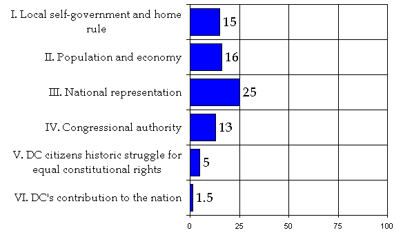
How Well Do Tourist Guidebooks Tell the Story of the District of Columbia?January 2000by Mark David Richards About the AuthorsMark Richards is a sociologist who has lived in a variety of District neighborhoods (Mt. Pleasant, Columbia Heights, Kalorama, Georgetown, Dupont Circle) for 15 years. He currently lives in Dupont East near the “17th Street Strip,” and works as senior associate at Bisconti Research, Inc., an opinion research firm, in Woodley Park. Richards was born in Pennsylvania, and has lived in North Carolina; Kentucky; Paris and Strasbourg, France; Bouaké, Ivory Coast; and Tombouctou and Diré, Mali. He speaks French. Richards authored “Making Up Our Mind in a Democratic Age: A Review of the Social Science Literature on Land Use Decision Making,” (June 1994); “Searching for Environmental Justice in a Democratic Age: Review of the Discourse on Environmental Inequality,” (July 1996); “Case Study of Neighborhood Identity: Washington, D.C.’s Dupont East Neighborhood” (April 1997); “How a Modern Electricity Company Went to the Roots of Democracy to Build Public Trust” (September 1997); and “Struggle for Democracy: A Local Sociopolitical History of Washington, D.C.” (1998). He also developed a series of fact sheets on DC, and is writing “Hope and Delusion in the Nation’s Capital: Struggle for Democracy in the District of Columbia,” his doctoral thesis for The Union Institute, which he is doing for fun. He doesn’t want to read another guidebook about DC for a long time. Cherith Richards is a student of sociology at The University of Maryland in College Park, where she resides. She works as Research Assistant for Bisconti Research, Inc. She was born in North Carolina, and lived in Greensboro where she researched discontinued patterns while working at Replacements Ltd., the “world’s largest china, crystal, and flatware company.” She also lived in Paris, France, Bouaké, Ivory Coast, and grew up in Tombouctou and Diré, Mali. She is one of a few Americans who speaks Songhai like a native Malian. She also speaks French. She has traveled throughout the Caribbean where she worked on a cruise ship for a couple years. Why and How We Conducted This EvaluationDC residents host over 20 million visitors annually. Visitors come to the nation’s symbolic center to see the federal institutions and to learn about the nation’s history and heroes. Washington, DC—known worldwide as the capital of Democracy—is packed with museums documenting the story of the ongoing American experiment in self-government. Most federal museums and monuments are located within the National Capital Service Area (NCSA). Outside the monumental core there are over one hundred neighborhoods that are not located in any state. These neighborhoods are animated by half-a-million residents who call the District home. The story of local DC parallels the story of the nation—but it is not the same story. It is a unique story that is both important and interesting. The objective of this study was to evaluate how well tourist guidebooks cover this story. To evaluate the guidebooks for benchmarking, a list of important historic and current sociopolitical facts about the District of Columbia was developed by Mark Richards and circulated among Stand Up for Democracy in DC Coalition members, grassroots and civic leaders, and individuals knowledgeable about DC. They reviewed the list of facts for comprehensiveness and accuracy. The facts (“factors”) clustered into the following six categories (“indicators”):
We visited bookstores with extensive tourist guidebook selections—Borders Books, B. Dalton Bookseller, Crown Books, and Kramerbooks & Afterwords, Lambda Rising—and purchased the latest editions of guidebooks to Washington, DC. We included “newcomers guides” and three guides published (available via Internet) by the Washington DC Convention and Visitors Association. We excluded single issue guidebooks (children, concierge, dining, mystery, etc.). Altogether, we evaluated 26 guidebooks. We read each one and identified statements of fact similar to those on our list and typed the quote and page number where the information can be found (see “Verbatim quotes from tourist guidebooks”). There are 40 statements of fact (factors). We calculated the percentage of tourist guidebooks that mentioned each factor. The total number of guidebooks (26) equals 100%. If a factor was mentioned in 10 of 26 guidebooks, that is 38% of the total. The 40 factors were clustered into six main indicators. The score for an indicator is the average of all the scores for each factor in that indicator. Numbers were rounded. Guidebooks Evaluated (For complete information, see end of report):
AcknowledgementsFrancine Cary, Editor of Urban Odyssey: A Multicultural History of Washington, D.C. and former Executive Director of the DC Humanities Council, encouraged me to pursue this project. Members of the Stand Up for Democracy in DC Coalition provided helpful review and comment, and provided needed encouragement to bring the project to fruition. George LaRoche, Attorney for the Adams v. Clinton lawsuit, spent a great deal of time reviewing the statements for detail, precision, and accuracy. His critique was tremendously helpful. My sister and colleague, Cherith Richards, a student of sociology at the University of Maryland, volunteered to help conduct the analysis. She spent hours doing the hard work of tabulating and transcribing quotes from the books. A host of individuals knowledgeable about DC history and civic life provided encouragement, review, and/or helpful comments. They include: Bob Arnebeck, Author, Through A Fiery Trial: Building Washington 1790-1800; Kenneth R. Bowling, Co-Editor, First Federal Congress Project and Author, The Creation of Washington, D.C.; Timothy Cooper, President, Democracy First, The Statehood Solidarity Committee; Winnie Gallant, Community Activist; Matthew Gilmore, Librarian, Washingtoniana Division, District of Columbia Public Library; Bette Hoover, Director of American Friends Service Committee/DC Peace & Economic Justice Program; Anise Jenkins, Community Activist and Secretary of Stand Up for Democracy in DC Coalition; Eugene D. Kinlow, Jr., Secretary and Trustee of the Committee of 100 and Community Activist; Florence Pendleton, Shadow Senator, District of Columbia; Jamin Raskin, Professor of Law, Washington College of Law, American University; Counsel for the Alexander v. Daley lawsuit; Peter Schott, Advisory Neighborhood Commissioner; Tom Sherwood, Author, Dream City: Race, Power, and the Decline of Washington, D.C.; NBC TV4 reporter; Kathryn Schneider Smith, Executive Director, DC Heritage Tourism Coalition; Editor, Washington At Home and Author, Port Town To Urban Neighborhood: The Georgetown Waterfront of Washington,D.C. 1880-1920; Sam Smith, Author, Captive Capital: Colonial Life in Modern Washington; The Statehood Papers: Articles On D.C. Statehood 1970-1991, and Editor, Free DC News Service, Paul Strauss, Shadow Senator, District of Columbia, and Karen Szulgit, Community Activist. In the end, inaccuracies are my responsibility and I welcome critique — learning is lifelong. Mark David Richards
Summary of FindingsIntroductionThe story of the District of Columbia is unique, important, and interesting. It is a story that a good writer can tell fairly well in a few pages. It is a story that few have heard, but many would be interested to know. Where would one expect visitors to Washington, DC to hear about this important story? One would expect tourist guidebooks to tell it—but do they? An article in The Washington Post (“Misguided,” April 19, 1998) pointed out that travel guidebooks in general are frequently unreliable and of a quality that is “widely uneven, ranging from highly detailed and insightful to disorganized compilations of public relations handouts.” Our question was specific to DC—how well do guidebooks to Washington, DC cover the local angle—DC’s story? And what do they tell? With this project, we set out to answer that question. The Invisible DistrictL’Enfant’s “City of Magnificent Distances” has been called many things. Most guidebooks mention that Charles Dickens called Washington City the “City of Magnificent Intentions.” From our study, local DC appears to be mostly invisible, hidden amorphously in the shadows of the spotlights focused on the federal institutions it hosts. Although not realistic to expect to find all we searched for, some information would seem to be important in understanding DC. DC’s story can be told with a few pages and in a timeline. Yet half of the facts that we searched for were not mentioned in even one of the 26 guidebooks, including:
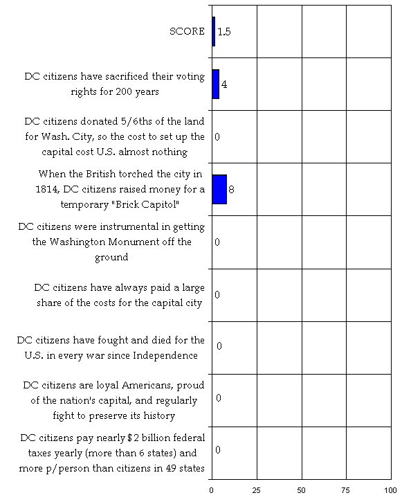
Perhaps most astonishing is that no guidebook recognizes DC citizens as having made any contributions to the Capital District. Their role as host to the nation’s federal institutions over 200 years has been completely omitted, despite that they sacrificed their most important right, equal citizenship, because when the federal Constitution was written the states felt exclusive legislative authority by Congress was needed for security reasons. Overall, guidebooks scored a 1.5 of a possible 100—that’s almost as low as they can go. Despite this grim assessment of coverage of DC’s story, some guidebooks were much better than others (see Table 1). Guidebooks from England and France, countries that have had a historic interest in the United States… scored highest in telling DC’s story. Also high on the list are guides from former British colonies—Canadian and Australian rooted guidebooks. Two guidebooks with regional roots scored quite high also. On the other hand, “newcomers guides,” Smithsonian guides, and DC’s own “official” guides chose to largely omit DC’s story and focus on the federal story or commercial interests. Here is a brief description of the guides from top to bottom:
3rd tier—Frommer’s Irreverent Guide, Guide to Black Washington, and Washington Historical Atlas—covered 20 percent. These guides were produced by regional authors. Irreverent is a bit funny and annoying at the same time (it takes potshots at locals). It is the only guide that tells “how to find out what’s really going on with the D.C. government”—by tuning in to WAMU’s FM 88.5 DC Politics Hour with Mark Plotkin Friday’s at noon, and it packs a lot of practical information into few pages. Guide to Black Washington tells some of the most in-depth and accurate sociopolitical information and shouldn’t be limited to an African-American audience. Graphically simple, it is organized by neighborhood, provides excellent information about places and people, and links these to African-American history. The Washington Atlas, like the Guide to Black Washington, should be on every local’s bookshelf. It is also organized by area, then by building or historic site. It provides a wealth of historic information, linked to specific buildings and neighborhoods, and provides a timeline. The Washington Atlas mentioned more DC neighborhoods than any other guide (40 of 114 neighborhoods mentioned). 4th tier—Let’s Go (18%), Econoguide (15%), National Geographic’s Driving Guide (15%,) and Travel and Leisure (15%). Let’s Go is written by 200 Harvard students and provides lots of good info and deals for the budget conscious traveler. Although printed on low-quality paper, it contains a wealth of information and maps. Like most of the guides, it has factual errors (this one jumped out: “In May 1870, Congress gave Washington the right to choose a mayor. Deputy Mayor Alexander “Boss” Shepherd took charge de facto in 1871.” Congress, in fact, picked a Governor FOR DC.) But, Let’s Go does discuss statehood—under the heading “State of Confusion.” Econoguide provides a nice little history of “the Capital City, the story of Washington, DC, “ but like others leaves most of the local DC story out. It provides discount coupons and good information, but is weak on maps. National Geographic is a high-gloss, well-designed publication that covers not only DC but also Virginia, West Virginia, Maryland and Delaware. Travel and Leisure, written by a former Washington Post staff writer, is a slim and trim, nicely written, hardback guide that is mostly upbeat about DC’s future. It offers a brief history, a timeline, and nice maps. 5th tier—Access and Insight Guides—covered 13 percent. Access is organized by neighborhood, offers maps, and has a 3-page timeline history. Insight is a high-gloss beautifully designed guide with excellent photographs and a pleasing narrative that weaves the local into the national. However, it is a bit select in what facts it chooses to tell and has a point-of-view that sounds a bit suburban DC—here’s how it describes “Washington’s four faces:” “There is the Washington that is most generally conjured up the name—the administrative city that governs the vast military and bureaucratic machine… Then there is social Washington, hovering not so discreetly behind the closed doors … of the exclusive salons of Georgetown, Kalorama and Embassy Row… The third Washington is referred to by both its white and its African American residents as ‘Chocolate City’ –- the 70 percent black Washington known as the crack and murder capital of the world. …But there is a fourth Washington, and it is this Washington that is finally forcing the capital into becoming a coherent, normal place to live, functioning beyond the shadow of the Capitol. It is the Washington that lies outside the District of Columbia line.” 6th tier—Smithsonian Guides to Historic America (5%), The Unofficial Guide (5%), Backstreet Guide (3%), Fodor’s City Guide (3%), and African-American Heritage and Multicultural Guide (3%) all have one thing in common—they don’t tell much about local DC. The Smithsonian Guide, titled “Virginia & the National Capital Region”(shouldn’t that be Washington, DC and the Capital Region?) is a high-gloss publication with beautiful photographs. The African-American Heritage and Multicultural Guide is a nice publication of the Washington DC Convention and Visitors Association, but it omits local sociopolitical history so important to African Americans in DC and so well articulated in the Guide to Black Washington. The Losers—The following guides excluded DC’s story altogether: Gay and Lesbian Traveler’s Guide (an otherwise excellent publication of the Washington DC Convention and Visitors Association), Mastering DC Newcomers Guide, Newcomer’s Handbook, Washington, DC: The American Experience, (also by the Washington DC Convention and Visitors Association), Washington on Foot (an otherwise wonderful book by the National Capital Area Chapter American Planning Association and Smithsonian Institution Press), and the Idiots Guide. The Idiots Guide informs readers that “This book isn’t for idiots. It just shows you how to visit a town full of them. Despite the crazy mentality here, I still get a thrill every time I’m in the city, and so will you.” Guidebooks one might expect to score high on telling DC’s local history, such as newcomer guides, Smithsonian guides, and those produced by DC’s own Convention and Visitors Association, scored in the bottom tiers. DC’s three guides, available over the Internet (www.washington.org), are attractive and free publications packed with useful information. The American Experience is mainly a resource book with listings. It does have a one page listing of 13 neighborhoods, which it uses as a legend throughout the guide. The Gay and Lesbian and Multicultural Guides demonstrate that DC is making an effort to be inclusive. Each one offers an interesting history of the respective identity group and their link to DC. The sociopolitical history is perhaps more important to these two groups than to others, yet there is little mention of it. The Multicultural Guide mentions home rule and ANCs in passing. Perhaps the abysmal scores by DC’s own can be attributed to fear of being perceived as “political,” or fear that if they mentioned the local story, important to residents, Congress might use its power to harm them in some way. It is well know that local officials and political elites factor in the Congressional presence into their local actions. Table 1
|
| Number Mentioned (40) | Percent Mentioned (100) | ||
| 1. | Michelin | 12 | 30 |
| Rough Guide | 12 | 30 | |
| 2. | Ulysses | 10 | 25 |
| Lonely Planet | 9 | 23 | |
| Berlitz | 9 | 23 | |
| Frommer’s Washington, DC from $60 a Day | 9 | 23 | |
| 3. | Guide to Black Washington | 8 | 20 |
| Washington Historical Atlas | 8 | 20 | |
| Frommer’s Irreverent Guide | 8 | 20 | |
| 4. | Let’s Go | 7 | 18 |
| Econoguide | 6 | 15 | |
| National Geographic’s Driving Guide | 6 | 15 | |
| Travel Leisure | 6 | 15 | |
| 5. | Access | 5 | 13 |
| Insight Guides | 5 | 13 | |
| 6. | Smithsonian Guides to Historic America | 2 | 5 |
| Unofficial Guide | 2 | 5 | |
| Backstreet Guide | 1 | 3 | |
| Fodor’s City Guide | 1 | 3 | |
| Multicultural Guide | 1 | 3 | |
| 7. | Gay and Lesbian Traveler’s Guide | 0 | 0 |
| Mastering DC Newcomer’s Guide | 0 | 0 | |
| Newcomer’s Handbook | 0 | 0 | |
| Washington on Foot | 0 | 0 | |
| Washington, DC: The American Experience | 0 | 0 | |
| Idiots Guide | 0 | 0 |
The Backstreet Guide, ranking next to last on sociopolitical issues, claims to give an “insider perspective,” because “[o]ur writers grew up in these cities, lived in them, and have loved them for years. The listings in this book come from the ‘insider’s perspective—from the native’s body of knowledge about the city—not from what other guides, magazines, newspapers, and ratings sources say,” and asks readers to think of them as your “all-knowing friends.” Backstreet provides useful information for newcomers, including information about some neighborhoods (Adams Morgan, Capitol Hill, Cathedral Heights, Cleveland Park, Dupont Circle, Foggy Bottom, Georgetown, Glover Park, Mount Pleasant, Tenleytown, Woodley Park) and the suburbs. About Mount Pleasant, the guide notes that “Property crime is more or less guaranteed.” About Foggy Bottom, it notes that “The odd name… dates to when the nation’s capital was little more than a swamp. …It is made up of students and well-heeled bureaucrats.”
Mastering DC, ranking last on informing newcomers about sociopolitical issues, points out that when it comes to neighborhoods, “there is something for everyone,” from urban neighborhoods to suburban cities and towns. Mastering DC provides information on a many of DC’s neighborhoods (it scores second highest on this measure, having mentioned 37 neighborhoods). It offers general maps showing neighborhood locations, as well as a good overview of the metro region. There is a chapter on “Dealing with the Local Bureaucracy.”
Newcomer’s Handbook also ranked last in our evaluation. It did, however, note that DC “isn’t just a government town anymore.” It reassures newcomers with “Don’t worry about being a newcomer—in Washington almost everybody is or was. There are native Washingtonians, of course, but they are greatly outnumbered… Few Washingtonians have old family or neighborhood ties in the area.” It says that “Washington isn’t one city. The Washington metropolitan area… is actually a city and two states… although they are very close geographically, they are oceans apart philosophically.” It notes that “DC is also more political. Residents only attained limited self government a few decades ago and they take their local politics seriously.” Newcomer says that “Washington’s crime is concentrated. …drive-by shootings and gang slayings … usually occur in the Northeast and Southeast quadrants… Most Washingtonians who live and work outside these areas of the city do not witness the daily violence firsthand. …And fewer people are willing to take a chance on moving into fringe communities like Mount Pleasant, Southwest…” It says that “Congress created [Rock Creek] park more than 100 years ago when the area was rapidly becoming the unofficial dump.” It provides information on Georgetown, Foggy Bottom, Dupont Circle, Adams Morgan, New U, Kalorama, Connecticut Avenue Corridor, Cleveland Park, American University Park, and Capital Hill, as well as the suburbs.
North/South Compromise, Virginia & Maryland Land—Most guides note that the location was born of a compromise between the north and the south, and land was ceded by Virginia and Maryland; many note that Virginia’s portion retroceded. Treatment of retrocession is quite different from guide to guide—Access says Virginians changed their minds and asked for it back, Fodor’s says the quarters of DC are very uneven because the southern quarters lost all their area to Virginia in the retrocession, Michelin says Alexandrians became disillusioned and felt they had suffered economically and politically as part of the District, Rough Guide says slave-owning Alexandrians were opposed to being in the District to begin with and few were sorry when Virginia demanded its land back, while The Unofficial Guide declares that Virginia “snatched its lands back.”
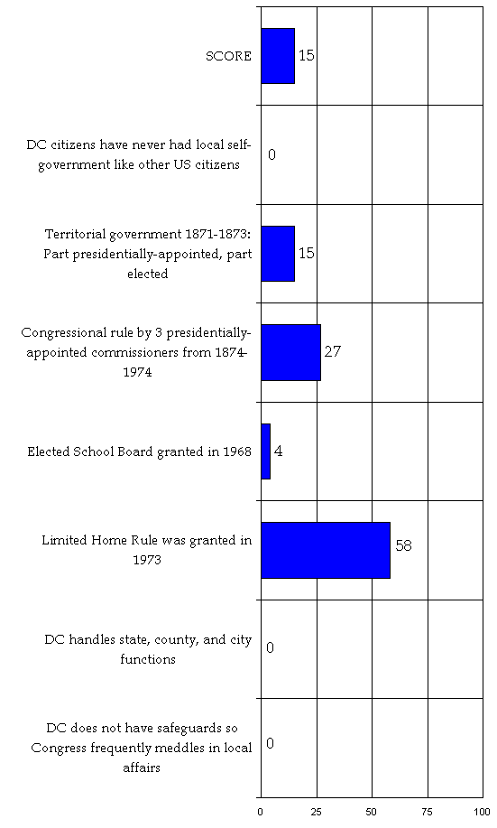
Home Rule—Although most guides didn’t explain “home rule” or what it means, over half mentioned that DC gained home rule in 1973.
The “Boss”—Forty-eight percent mentioned the Territorial government, the wonderful municipal improvements made by “Boss” Shepherd, and many attributed his work to making the city a real city. Quite a few mention the debt he created, but only 10 percent mentioned that he was appointed by the President, not elected, and only The Guide to Black Washington explained how the “Boss’s” mismanagement was used by Congress to blame the city and snatch away the vote, mainly to cut out newly enfranchised blacks. The different ways in which guidebooks treat “The Boss” is interesting (see detailed quotes for the flavor).
| Percent Guidebooks Mentioned Subject | |
| The land for DC was ceded by Virginia and Maryland | 62 |
| DC gained home rule in 1973 | 58 |
| The Virginia portion of DC retroceded in 1846 | 54 |
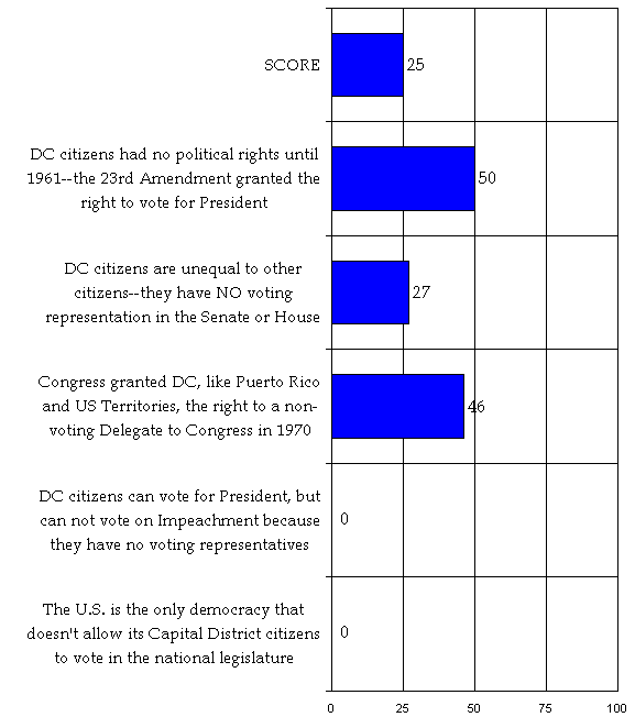
| DC Citizens were given the right to vote for President in 1961 | 50 |
| Congress granted DC right to non-voting Delegate in 1970 | 46 |
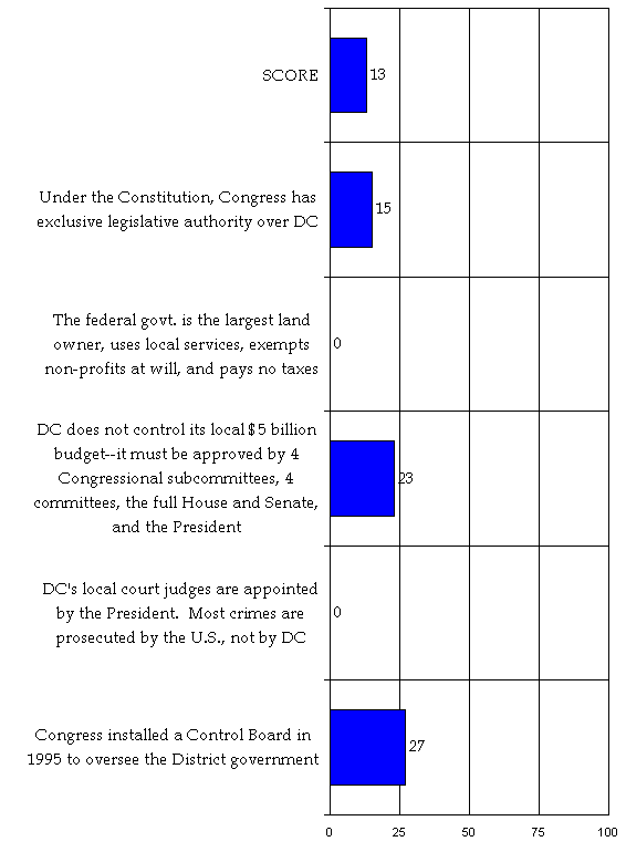
| Congress ruled DC from 1874-1974 | 27 |
| DC citizens have no voting representatives in Congress | 27 |
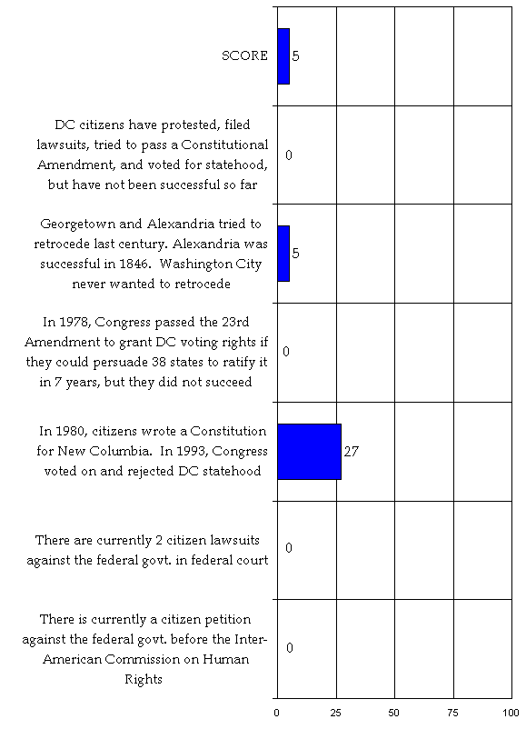
| Congress installed a Control Board in 1995 | 27 |
| In 1993 Congress voted on and rejected statehood for DC | 27 |
| DC does not control its local budget | 23 |
| Congress has exclusive legislative authority | 15 |
One common problem in the guidebooks is that local DC is frequently blurred with the federal government. Very often, DC history is merged into text about federal history, with no distinction made—as if the authors couldn’t quite sort out the differences. Often DC is presented as Uncle Sam’s “company town,” subsidized by the American public, and the federal image—politicians, bureaucrats, lawyers, and deal makers—is superimposed onto local DC.
Frommer’s Irreverent Guide, which claims to be written by “insiders,” with “nothing to sell but the truth” quotes the 1951 Washington Confidential, informing visitors that Washington is “’a made-to-order architectural paradise with the political status of an Indian reservation, inhabited by 800,000 economic parasites; no industries but one, government, and the tradesmen and servants and loafers and scum that feed on the highest average per capita income in the world, where exist the soundest security, the mightiest power, and the most superlative rates of crime, vice, and juvenile delinquency anywhere.’ (Things are different now; there are only about 600,000 parasites.) …Washington is also a city of paper pushers (okay, computer inputters now). It produces hardly anything except laws, policy, and opinions.”
Of the six indicators to measure coverage of DC’s sociopolitical history, not one scored over 25 out of a possible 100, indicating little depth of coverage on the issues.
We incorporated a simple measure to evaluate the scope of neighborhood coverage. We identified which guides mentioned the most neighborhoods (Table 3) and which neighborhoods were mentioned most frequently overall (Table 4). Neighborhoods mentioned most were usually given most extensive coverage, while others were mentioned in passing or in reference to a building or historic event. We did not evaluate quality of neighborhood coverage.
Number of Neighborhoods Mentioned in Each Guide (Out of 114 Checked)
| 1. | Washington Historical Atlas | 40 | 35 |
| 2. | Mastering DC Newcomers Guide | 37 | 32 |
| 3. | Let’s Go | 28 | 24 |
| 4. | Insight Guides | 25 | 22 |
| 5. | Rough Guide | 23 | 19 |
| 6. | Access | 22 | 17 |
| 7. | Fodor’s City Guide | 20 | 16 |
| 8. | Guide to Black Washington | 19 | 15 |
| 9. | Newcomer’s Handbook | 18 | 14 |
| 10. | Backstreet Guides | 17 | 14 |
| 11. | Lonely Planet | 16 | 14 |
| 12. | Frommer’s Washington, DC, from $60 a Day | 16 | 14 |
| 13. | On Foot | 16 | 14 |
| 14. | Michelin | 13 | 11 |
| 15. | Econoguide | 13 | 11 |
| 16. | Washington, DC: The American Experience | 12 | 10 |
| 17. | Unofficial Guide | 11 | 9 |
| 18. | Travel & Leisure | 11 | 9 |
| 19. | Frommer’s Irrelevant Guide | 11 | 9 |
| 20. | Ulysses | 9 | 8 |
| 21. | Gay and Lesbian Traveler’s Guide | 9 | 8 |
| 22. | Multicultural Guide | 9 | 8 |
| 23. | Idiot’s Guide | 9 | 8 |
| 24. | Berlitz | 6 | 5 |
| 25. | Smithsonian Guides to Historic America | 5 | 4 |
| 26 | National Geographic’s Driving Guides | 2 | 1 |
| Number Guidebooks Mentioned This Neighborhood (26) | % Guidebooks Mentioned This Neighborhood (100) | ||
| 1. | Capitol Hill | 26 | 100 |
| 2. | Georgetown | 26 | 100 |
| 3. | Dupont Circle | 26 | 100 |
| 4. | Adams Morgan | 23 | 88 |
| 5. | Foggy Bottom (Funkstown, Hamburg) | 22 | 85 |
| 6. | Downtown, Penn Quarter | 21 | 81 |
| 7. | Chinatown | 19 | 73 |
| 8. | Anacostia | 16 | 62 |
| 9. | Southwest/Southwest Washington | 16 | 62 |
| 10. | Woodley Park | 14 | 54 |
| 11. | Union Station | 13 | 50 |
| 12. | Shaw/U Street/Cardoza | 11 | 42 |
| 13. | Kalorama/Kalorama Heights | 11 | 42 |
| 14. | Southeast | 10 | 38 |
| 15. | Glover Park | 8 | 31 |
| 16. | Lincoln Park | 8 | 31 |
| 17. | Mount Pleasant | 8 | 31 |
| 18. | Brookland | 8 | 31 |
| 19. | Cleveland Park | 8 | 31 |
| 20. | LeDroit Park | 8 | 31 |
| 21. | Logan Circle | 7 | 27 |
| 22. | Northwest Triangle/Northwest | 7 | 27 |
| 23. | Scott Circle | 7 | 27 |
| 24. | Northeast | 6 | 23 |
| 25. | Columbia Heights | 5 | 19 |
| 26. | Friendship Heights | 5 | 19 |
| 27. | Mt. Vernon Square | 4 | 15 |
| 28. | Thomas Circle | 4 | 15 |
| 29. | Washington Circle | 4 | 15 |
| 30. | West End | 4 | 15 |
| 31. | Fort Dupont Park | 3 | 12 |
| 32. | Judiciary Square | 3 | 12 |
| 33. | Lanier Heights | 3 | 12 |
| 34. | McLean Gardens | 3 | 12 |
| 35. | Shepherd Park | 3 | 12 |
| 36. | Tenleytown | 3 | 12 |
| 37. | American University Park | 2 | 8 |
| 38. | Brightwood | 2 | 8 |
| 39. | Cathedral Heights | 2 | 8 |
| 40. | Fort Davis Park | 2 | 8 |
| 41. | Franklin and McPherson Square | 2 | 8 |
| 42. | Potomac Palisades | 2 | 8 |
| 43. | Spring Valley | 2 | 8 |
| 44. | Stanton Park | 2 | 8 |
| 45. | Barry Farms | 1 | 4 |
| 46. | Capitol View | 1 | 4 |
| 47. | Chevy Chase | 1 | 4 |
| 48. | Congress Heights | 1 | 4 |
| 49. | Farragut Square | 1 | 4 |
| 50. | Foxhall/Georgetown Reservoir | 1 | 4 |
| 51. | Good Hope | 1 | 4 |
| 52. | Kenilworth | 1 | 4 |
| 53. | Kingman Park | 1 | 4 |
| 54. | Lincoln Heights | 1 | 4 |
| 55. | Michigan Park | 1 | 4 |
| 56. | Takoma | 1 | 4 |
| 57. | Van Ness | 1 | 4 |
| 58. | Wesley Heights | 1 | 4 |
| 59. | Barnaby Woods | 0 | 0 |
| 60. | Barney Circle | 0 | 0 |
| 61. | Bellview | 0 | 0 |
| 62. | Benning | 0 | 0 |
| 63. | Benning Heights | 0 | 0 |
| 64. | Brentwood Village | 0 | 0 |
| 65. | Brightwood Park | 0 | 0 |
| 66. | Burleith | 0 | 0 |
| 67. | Buena Vista | 0 | 0 |
| 68. | Burrville | 0 | 0 |
| 69. | Carrollsburg | 0 | 0 |
| 70. | Children’s Hospital | 0 | 0 |
| 71. | Chillum | 0 | 0 |
| 72. | Colonial Village | 0 | 0 |
| 73. | Crestwood | 0 | 0 |
| 74. | Deanwood | 0 | 0 |
| 75. | Douglass | 0 | 0 |
| 76. | East End | 0 | 0 |
| 77. | Eastland Gardens | 0 | 0 |
| 78. | Eckington | 0 | 0 |
| 79. | Edgewood | 0 | 0 |
| 80. | Fairmont Heights | 0 | 0 |
| 81. | Fairfax Village | 0 | 0 |
| 82. | Floral Hills | 0 | 0 |
| 83. | Forest Hills | 0 | 0 |
| 84. | Garfield Heights | 0 | 0 |
| 85. | Grant Park | 0 | 0 |
| 86. | Greenway | 0 | 0 |
| 87. | Hawtorne | 0 | 0 |
| 88. | Hillbrook | 0 | 0 |
| 89. | Hillcrest | 0 | 0 |
| 90. | Ivy City | 0 | 0 |
| 91. | Knox Hill | 0 | 0 |
| 92. | Lamond | 0 | 0 |
| 93. | Langdon | 0 | 0 |
| 94. | Mahaning Heights | 0 | 0 |
| 95. | Manor Park | 0 | 0 |
| 96. | Marshall Heights | 0 | 0 |
| 97. | Massachusetts Heights | 0 | 0 |
| 98. | Naylor Gardens | 0 | 0 |
| 99. | North Cleveland Park | 0 | 0 |
| 100. | Park View | 0 | 0 |
| 101. | Petworth | 0 | 0 |
| 102. | Pinehurst Circle | 0 | 0 |
| 103. | Randle Highlands | 0 | 0 |
| 104. | Rock Creek Gardens | 0 | 0 |
| 105. | Shipley Terrace | 0 | 0 |
| 106. | Summit Park | 0 | 0 |
| 107. | Trinidad | 0 | 0 |
| 108. | Truxton Circle | 0 | 0 |
| 109. | Twining | 0 | 0 |
| 110. | University Heights | 0 | 0 |
| 111. | Washington Highlands | 0 | 0 |
| 112. | Westminster | 0 | 0 |
| 113. | Woodridge | 0 | 0 |
| 114. | Woodland | 0 | 0 |
For each of the six indicators: first is the list of facts that we searched for in the indicator, followed by the score (shown graphically) based on the total number of mentions in 26 guides.
Fully italicized quotes indicate that the item was not accurate enough or did not contain enough vital information from the factor to be counted in the score.
1. Throughout their history, citizens of the District of Columbia have never enjoyed local self-government like other American citizens, and have had home rule, similar to the original colonial governments, at the discretion of Congress.
Frommer’s Washington D.C. From $60 a Day
“Washington, D.C., is at once the capital of our country and a city unto itself, and therein lies a host of complications. Control is the main issue. Because it is the seat of our country’s government, Washington is under Congress’s thumb (by order of the U.S. Constitution), which means, in particular, that Congress controls the city budget. …” (p. 3)Insight Guides
“…As far back as 1865—when DC citizens didn’t even have the right to vote in federal elections—it was generally accepted that home rule meant some degree of black rule, a situation that ignited bitter debate in Congress over black suffrage in Washington. Today, of course, the situation is quite different. Washington residents vote in local and federal elections; the mayor and city council initiate local legislation. But District government is still not autonomous…” (p. 55)Lonely Planet
“As a political entity, DC is an anomaly that operates more like a colony or Indian reservation—a reservation of 600,000 people… Congress justifies its decisions by pointing to DC’s track record, which is far from sterling. As early as the 1870s, an elected mayor who earned the nickname ‘Boss’ Shepard so liberally disposed of federal funds that Congress revoked ‘home rule’ for another century. More recently, the District has been rocked with scandals of financial mismanagement, drug use, and such irresponsible administration that the nation’s capital is left with barely adequate public services, from garbage or snow removal to firefighting and police protection.” (p. 106)Rough Guide
“Born of compromise, it was built as an experiment, and in many ways continues as one—careering along in political turmoil, without representation, bankrupt, neglected, socially psychotic: a federal basket case. These attributes don’t necessarily preclude a city from greatness—look at New York—but in Washington’s case, history and politics have combined to produce a city full of fine buildings, soaring monuments and improving experiences but short on soul and long on contradictions.” (p. ix)Travel & Leisure
“To add insult to injury, the District of Columbia was made a politically neutral federal district—residents did not have the right to vote in congressional or presidential elections (the idea was to protect the government from local interference). Belonging to no state, the District was given short shrift by Congress, which was preoccupied with other matters. The miserliness with which the city was (and arguably, still is) treated was astonishing. ....” (p. 290-291)
2. In 1871, Congress placed all jurisdictions in the District of Columbia under one
“Territorial government” with a Presidentially-appointed
Governor and upper house, and an elected lower house. Free black men were allowed to vote
for the first time in the lower house only, where there was a biracial coalition.
Access
“1867: Congress gives Washington residents the right to vote.” (p. 215)
“1871 – Congress creates a territorial government for the District. All local officials are appointed by the president.” (p. 215)Berlitz Pocket Guide
“In 1871, Ulysses S. Grant, now president, appointed a new city government for DC, and its administrator, Alexander “Boss” Shepherd, set about providing the roads, street lights, and sewers that had been lacking for so long. …Civic and national pride in the city increased.” (p. 16)Econoguide
“In 1867, under Ulysses S. Grant’s administration, Congress granted the District of Columbia territorial status, consisting of a governor appointed by the president, a council, and boards of public works and health. Between 1871 and 1874, the Board of Public Works built sewers and sidewalks, condemned 400 unsanitary buildings, paved streets, and planted 60,000 trees.” (p. 16)Frommer’s Washington D.C. From $60 a Day
“The war’s legacy to the capital was poverty, unemployment, and disease. The parks were trodden bare, a red-light district remained, and tenement slums emerged within a stone’s throw of the Capitol. … Enter “Boss” Shepherd and a new era. Governor Alexander R. Shepherd was chosen to head a territorial government established in the District of Columbia from 1871-1874. Shepherd was a handsome, strapping man with blustery charm. He’d been a successful plumber, an alderman, a newspaper owner, and president of the City Reform Association. He was a natural to become leader of the territorial government. Once installed in office, though, he ignored budgets and set out to beautify his domain by following a path that would lead to bankruptcy. Under his guidance, L’Enfant’s plan was finally executed in earnest…” (p. 9-10)Guide to Black Washington
“In 1871 the city’s three jurisdictions—Washington County, the city of Washington, and Georgetown—were united under a territorial government in which the governor and council continued to be appointed by the president. The franchise was extended to all male residents, including blacks, and the city gained a non-voting representative in the Congress. Due to a variety of events and factors, Congress took back its power over the capital’s affairs in 1878, establishing a presidentially-appointed commission system of local government. Although the citizens lost their right to self-rule, they gained a federal subsidy payment equal to half the city’s expenses.” (p. 29)Let’s Go
“After fleeing to freedom in wartime DC, refugee slaves gathered in spontaneous shanty towns such as Murder Bay, a few blocks from the White House. The post-war period briefly spelled better times for black people: the five years after 1868 were called the ‘Golden Age of Black Washington’. …In May 1870, Congress gave Washington the right to choose a mayor. Deputy Mayor Alexander “Boss” Shepherd took charge de facto in 1871. Protected by his friendship with President Grant, Shepherd resurfaced the streets, planted trees, and employed thousands of laborers in his super-efficient city improvement plan. He tore down decrepit buildings, built sewers and parks, installed streetlights—and sent the city into record-breaking debt. The federal bailout that followed returned control of the city to Congress and robbed DC of self-government for over 100 years. (p. 3)Michelin
“The brief period of territorial government that began in 1871 was dominated by Alexander “Boss” Shepherd, the driving force behind a citywide public works program that resulted in the development of such outlying areas as Dupont Circle; the alteration of street levels to improve drainage; the paving over of the old, unsanitary canal; and the planting of thousands of trees. Shepherd’s grand plan also bankrupted the city, which, as always, relied on federal coffers for support.” (p. 24)
“1871-1874: An act of Congress establishes a brief period of territorial government for the District. Alexander “Boss” Shepherd begins a major citywide public works project that results in much beautified but near-bankrupt city.” (p. 19)National Geographic’s Driving Guides to America
“Colorful characters of one sort or the other have long dominated the Washington political scape. One man that typified the best and worst in capital shenanigans was Alexander “Boss” Shepherd, who rose to power during the Grant Administration. Congress had just granted the city independent territorial status, and the high-rolling Shepherd, as overseer of public works, set about improving the city—filling in the unsanitary canal that ran through the heart of town, altering street levels, planting trees, and developing the outlying area around current-day Dupont Circle. While Shepherd’s schemes were edifying, they also bankrupted the city, and hence the reputation of the ‘Boss.’” (p.40)
“Following the Civil War, Congress briefly granted the city territorial status, but within several years, bankruptcy threatened and territoriality was revoked.” (p. 28)On Foot
“Under the territorial form of government imposed upon the District of Columbia in 1871 and the ambitious public works programs of Alexander Robey Shepherd, executive officer of the Board of Public Works, the fortunes of 16th Street and Meridian Hill took a different direction.” (p. 107)Rough Guide
“Under President Grant in 1871 the District was given territorial status: he appointed a governor and council, under whom worked an elected house of delegates, and boards of public works and health; all adult males (black and white) were eligible to vote. Many of the most significant improvements to the city infrastructure date from this period of limited self-government, with head of the Board of Public Works, Alexander “Boss” Shepherd, instrumental in sinking sewers, paving and lighting streets and planting thousands of trees.” (p. 182)Smithsonian Guides to Historic America
“It was not until the early 1870s that Washington began to be transformed into a true city. This was largely the work of one many, Alexander Shepherd, a close friend of President Grant. As vice president of the board of public works, Shepherd dispatched crews throughout the city to entrench sewer, water, and gas lines, lay sidewalks, and grade roads. He cared little for the niceties of a bureaucracy, a budget, or the law, but he could get things done. Road grading was carried out with little or no regard for the houses along the road… Shepherd’s public works campaign coincided with, and spurred, a short-lived black renaissance in the city. From its very foundation the capital city has been a testing ground for the nation’s race relations. … During and just after the Civil War, freed slaves flocked to the capital, where the black population in 1867 reached nearly forty thousand, about a third of the city’s total population. Though a black middle class began to emerge, most lived in poverty, and a great many died quickly when disease swept through their shanty settlements. …In 1867 … blacks were enfranchised in the city. In 1870 segregation in public places was made illegal. Frederick Douglass, elected to the city council, was an official pallbearer at the funeral of Vice President Henry Wilson. For a brief time Washington was known as ‘the colored man’s paradise.’ But fears that blacks would use their vote and economic power to ‘take over’ the city led to a resurgence of discrimination and segregation.” (p. 25-26)Travel & Leisure
“The miserliness with which the city was (and arguably, still is) treated was astonishing. …The city languished without proper amenities until the 1870s, when a dynamic city administrator named Alexander (“Boss”) Shepherd forced through a vast scheme of public works without worrying about where the money would come from. Sidewalks were laid, sewers and street lights installed, and thousands of trees planted. Although he bankrupted the city, posterity should be grateful to Shepherd.” (p. 291)Ulysses
“The year 1871 marked the beginning of another eventful period in the history of the District of Columbia, which was awarded the status of a territory and given permission to elect a local government. Alexander Shepherd launched major construction projects to provide Washington with an infrastructure worthy of a federal capital. Washington ended up much more beautiful than before, but broke. Congress revoked its old territorial status in 1874.” (p. 31)Washington Historical Atlas
“Before plans to move the capital could get past the talking stage, Congress struck at the root of Washington’s problems: its city government. Cast adrift within the larger firmament of the national government, the local government was often at a loss for self-regulation. In April of 1871, Congress passed legislation creating the Territory of Washington, giving the city an official status in and of itself, including a non-voting delegation of one to Congress. The Territorial Act also provided for the creation of several oversight boards, including a health commission—whose responsibilities included getting farm animals out of the roads—and a five-member Board of Public Works. Under the iron rule of the irrepressible Alexander “Boss” Shepherd, the Board of Public Works almost single handedly changed the face of Washington. …” (p. xi)
3. In 1874 at the end of Reconstruction and the demise of control by the Radical Republicans, the majority of Congress and local elites were fearful of the free black vote. When Alexander “Boss” Shepherd ran the city into debt by improving the local infrastructure which had become dilapidated during the Civil War, this provided the excuse to remove home rule for the next century. Congress abolished the vote and installed three commissioners, appointed by the President. This was at first temporarily, but made permanent in 1878.
Access
“1874 – The territorial form of government is abandoned. Congress resumes direct control of the District. A panel of three commissioners appointed by the president administers the city. Voting rights for Washington residents are stripped.” (p. 215)Frommer’s Irreverent Guide
“DC had home rule, with an elected mayor and council, from 1802 until a presidential commission decided to take over in 1874.” (p. 3)Frommer’s Washington D.C. From $60 a Day
“Before long, Congress reacted, and Shepherd was nearly booed out of town. In 1874, the territorial form of government was replaced with a trio of commissioners. Shepherd retreated with his family to Mexico, but when he returned to the United States in 1887, he was acclaimed as the man who had made Washington a showplace. And he certainly had.” (p. 10)Guide to Black Washington
“Throughout the Civil War, Washington’s black population increased dramatically as freed slaves who were refugees from the Confederate states streamed into the city, and in 1862, Congress emancipated the capital’s remaining bondsmen. Between 1860 and 1870, the number of African American residents more than tripled, until they comprised almost one-third of the city’s total population.” (p. 17)
“By the mid-to-late 1870s, however, the United States Congress, which retained constitutional authority over the District of Columbia, used local political turmoil, mismanagement, and corruption as excuses to snatch away the limited self-government that it previously had granted the city. The congress thus alleviated any apprehensions about possible political control by Washington’s increasing black population which by 1875 approached forty percent. Three white, federally appointed commissioners replaced the locally elected officials. Segregation of most public accommodations became common practice during the 1870s and 1880s, and in the century’s final decades black Reconstruction members of congress from southern states gradually were removed from office.” (p. 18)Let’s Go
“Deputy Mayor Alexander “Boss” Shepherd took charge de facto in 1871. …The federal bailout that followed returned control of the city to Congress and robbed DC of self-government for over 100 years. (p. 3)Michelin
“… Shepherd’s grand plan also bankrupted the city, which, as always, relied on federal coffers for support. A disgruntled Congress revoked territorial government and returned the city to district status in 1874. In 1871 Washington was significantly enlarged by the incorporation of Georgetown.” (p. 24)National Geographic’s Driving Guides to America
“While Shepherd’s schemes were edifying, they also bankrupted the city, and hence the reputation of the ‘Boss.’ In 1874 Congress revoked territorial status and placed the capital city firmly back under congressional control.” (p.40)Rough Guide
“Under President Grant in 1871 the District was given territorial status: … However, Shepherd’s improvements and a string of corruption scandals put the city $16 million in debt. Direct control of DC’s affairs passed back to Congress in 1874, which later appointed three commissioners to replace the locally elected officials.” (p. 182)Travel & Leisure
“Although he bankrupted the city, posterity should be grateful to Shepherd. The response of Congress, however, was to dissolve the city council and take over the government of the District through congressional committees, thus leaving the citizens with neither federal not local representation – an extraordinary state of affairs for the capital of a great democracy.” (p. 291)
“1878—Government of D.C. by commissioners appointed by the president was re-established, leaving residents with no say in the running of the city or the nation.” (p. 295)Washington Historical Atlas
“In 1874, President Ulysses S. Grant appointed Shepherd Territorial Governor. Shepherd’s municipal spending spree, however, had already caught up with the Territory of Washington, which found itself broke and a national laughingstock. That same year, Congress called for an investigation, and Shepherd’s shady methods were exposed. Congress called him up on allegations of corruption, and even some of Shepherd’s close associates supplied evidence against the man who had made Washington livable. Shepherd was practically run out of town, although he did return years later to a hero’s welcome. The federal government bailed out the wayward city that year, but took away its territorial status (including home rule). It was not until 1964 that citizens of Washington were allowed the right to vote in national elections, and the city itself did not regain home rule until 1975.” (p. xi)
“1874: ‘Boss’ Shepherd’s mismanagement and bankrupting of city’s funds leads him to flee to Mexico, and the federal government revokes the city’s home rule.” (p. 333)
4. After the schools had been neglected for years, Congress granted DC residents the right to elect a Board of Education in 1968, the same year as Rev. Martin Luther King Jr. and Robert Kennedy were assassinated and riots erupted in most major U.S. cities.
Guide to Black Washington
“Events of the 1960s and early 1970s substantively altered Washington’s political face. The president appointed the District’s first black commissioner in 1961. In 1964 a constitutional amendment gave the city’s residents the right to vote for president, and an elected school board came into being in 1968—the same year that urban riots following the assassination of Rev. Martin Luther King, Jr. vividly exposed the pent-up frustrations of so many black Americans.” (p. 20)
“By the early 1960s Washingtonians were granted the right to vote for president and vice president, followed by an elected school board in 1968.” (p. 29)
5. Congress allowed DC residents to have limited home rule in 1973, in part because the 3 commissioner government was corrupt and financially mismanaged. Today, DC has an elected mayor, a 13-member elected city council (1 for each of 8 Wards, 4 At-large, and 1 Council Chair), and an 11-member elected school board (1 for each of 8 Wards and 3 At-large). DC also elects 299 neighborhood Advisory Neighborhood Commissioners—1 for each single member district (SMD) of about 2,000 residents. There are 37 Advisory Neighborhood Commissions with 2-14 commissioners, depending on neighborhood size. They have no voting power, but the city government is supposed to give their opinions and deliberations “great weight.”
Access
“1967: Congress reorganizes the District’s government. The three-commissioner system is replaced with a mayor, an assistant commissioner, and a city council, all appointed by the president. Although pressure grows for self-rule, it remains elusive.” (p. 216)
“1973: Limited local self-rule is achieved. Residents of the District are given the right to vote for their local leaders. Congress reserves the right to veto any action that threatens the federal interest. Moreover, the city budget must be reviewed and enacted by Congress.” (p. 216)
“1975: Walter Washington is the first popularly elected mayor of Washington, DC.” (p. 216)Berlitz Pocket Guide
“The people of DC gradually gained—or regained—most of the democratic rights of ‘normal’ US citizens over this period. They could at last vote in a presidential election, then for a Representative in Congress (though still not one with a full vote). In 1975, they could vote again for a city council and mayor. There is movement afoot to make DC a state, so that it can also be represented in the Senate.” (p. 18)Econoguide
“The concept for the federal city was that it would be a separate entity, not part of any individual state. The District of Columbia was originally governed by the Congress. (In recent years, the District was given limited ‘home rule’ under supervision of a congressional committee. Residents can cast votes for President and Vice President, but have on a nonvoting delegate in the House of Representatives.) (p. 15)Frommer’s Irreverent Guide
“…full home rule, with an elected mayor and city council, was restored in 1975, though the arrangement is pretty unwieldy—Congress still has the right to approve the entire city budget. Home Rule II has been a mixed blessing, partly due to the character of the elected home rulers themselves.” (p. 3)Frommer’s Washington D.C. From $60 a Day
“[A]n elected mayor and council govern the city, thanks to Congress’s granting of home rule to DC in 1973.” (p. 3)Guide to Black Washington
“…in 1974, voters finally had the opportunity to elect a mayor and city council under provisions of new Home Rule legislation. Nonetheless, the congress still retains strong control over the District’s purse stings as well as legislative veto power over local political actions.” (p. 20)
“With the passage of the Home Rule Act of 1973, the city gained an elected mayor and city council, but Congress retained veto power over city laws and authority over the city’s budget. The nation’s capital was among the first major cities in the country to be governed by a black mayor when Walter E. Washington was elected in 1974.” (p. 29)Insight Guides
“Today, of course, the situation is quite different. Washington residents vote in local and federal elections; the mayor and city council initiate local legislation. But District government is still not autonomous. Under the Home Rule Act of 1974, the US Congress has the power to review and amend District legislation, including the budget. Supporters of limited home rule cite Washington’s history as a federal district and Congress’s obvious interest in the management of the capital. The charge is still being made, however, that influential factions in Congress and in the city are simply unwilling to hand over the reins of power to black leaders.” (p. 55)Let’s Go
“A century of Congressional rule came to an end with the passage of the 1973 Home Rule Act, which gave DC an elected mayor, a city council, and a non-voting delegate in Congress. The first mayor, Walter Washington, represented the middle-class black establishment. He was replaced in 1978 by Marion Barry, a prominent 60s civil-rights leader. His platform was staunchly liberal, but his first term was noted for attracting business to the city. By the mid-80s, however, the shine had worn off the Barry administration.” (p. 5)Michelin
“After a century of Congressional rule, Washington was given the federally mandated authority to govern itself under the Home Rule Act of 1973. The city government now comprises an elected mayor and a 13-member legislative council, a board of education, and a series of advisory neighborhood commissions. Though the city functions somewhat independently of the Federal legislature, Congress retains veto power over bills passed by the District council.” (p. 12)
“1973: Congress passes the Home Rule Act, establishing self-government for DC.” (p. 20)Multicultural Guide
“In 1974, after years of pressure form the citizens of Washington, D.C., Congress granted the city the right to elect a city council and mayor for the first time in 100 years. African Americans in the nation’s capital felt a renewed commitment to public service and eagerly worked in organizations like Advisory Neighborhood Councils.” (p. 8)National Geographic’s Driving Guides to America
“In 1974 Congress granted the city ‘home rule.’ An elected mayor and city council now run local affairs and can set local taxes, but Congress ultimately controls the budget and the purse strings.” (p. 28)Rough Guide
“[In] 1973 … Congress passed the Home Rule Act. Small improvements had already been effected – the first black commissioner (for a city now predominantly black) was appointed in 1961; later, an elected school board was established. But only in 1974 with the advent of the District’s first elected mayor for more than a century – the black Walter E. Washington, supported by a fully elected thirteen-member council – did they city wrest back some measure of self-autonomy. However, Congress still retained a legislative veto over any proposed local laws as well as a close watch on spending limits. Washington was succeeded as mayor by Marion Barry in 1978 former Civil Rights activist and as picaresque as a political leader as any city could wish for. At first, he was markedly successful in attracting much-needed investment; he also significantly increased the number of local government workers, which gave him a firm support base among the majority black population. But longstanding whispers about Barry’s turbulent private life—in particular, charges of drug addiction—exploded in early 1990, when he was surreptitiously filmed in an FBI sting operation, buying crack cocaine. Barry spent six months in prison, and was replaced as mayor the Democrat Sharon Pratt Kelly, who signally failed to improve the city’s worsening finances. In the mayoral election of 1994, Barry made an astounding comeback, admitting to voters the error of his ways. But a year later, Congress—influenced by the sweeping Republican gains in the previous year’s election—finally tired of the embarrassment of DC’s massive budget deficit (standing at $700 million) and revoked the city’s home rule charter.” (p. 183)Travel & Leisure
“1975 – Washington regained an elected city council, and Walter Washington, an African-American, was elected the city’s first mayor in more than a century.” (p. 296)
“Today it has its own elected mayor and city council drawn largely from the African-American areas, and DC residents can at last vote in presidential elections, although they still have only ‘shadow’ representation in Congress.” (p. 292)Ulysses
“For nearly a century, the US Congress administered the city of Washington and the District of Columbia like its private domain. …In 1973, however, things changed. The Home Rule Act allowed the population to elect city councilors and a school board. Congress nonetheless reserved its veto power over municipal administration. Furthermore, municipal budgets are always under the president’s control. Finally, the preservation of the capital’s heritage and standing has led to the creation of specific regulations and several special commissions that are not within municipal jurisdiction. The mayor’s political powers are therefore much more limited than in any other American city.” (p. 48)Washington Historical Atlas
“… It was not until 1964 that citizens of Washington were allowed the right to vote in national elections, and the city itself did not regain home rule until 1975.” (p. xi)
“1975: Home rule is restored to Washington, D.C., and the people elect Walter Washington as the city’s first twentieth-century mayor.” (p. 336)
6. DC handles most state, county, and city functions in this one municipal government. For legal and comparative purposes, the federal government defines DC as a state for application of over 500 federal statutes.
Frommer’s Washington D.C. From $60 a Day
“As President Clinton put it in a December 1996 press conference, Washington suffers from a ‘not quite’ factor: the capital is not quite a city and not quite a state, but something else altogether.” (p. 3)National Geographic's Driving Guides to America
“A unique geopolitical entity, Washington is neither a city nor a state, but a district—a designation that has led to no end of confusion and controversy.” (p. 28)
7. Because DC does not have safeguards against the federal government like states do, Congress intervenes against the will of local citizens through the budgeting process and by vetoing legislation approved by the elected City Council.
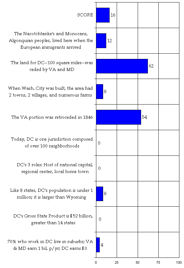
1. As documented by John Smith and Thomas Jefferson, the area that is now Washington, DC was home to many indigenous Algonquian tribes, with an estimated population of 12,000. The name Potomac means a trading place. The land of present Georgetown was called “Tohogee,” settled by the Monocans. The Nacotchtanke’s lived in the section of DC now called by the name they were given by Catholic missionaries—Anacostia. All portions of the valley were inhabited, and anthropologists have found “inexhaustible” supplies of relics. European settlers adapted Indian forms of agriculture, construction, transportation, words, government, and oratory. In 1666, members of the Piscataway confederation wrote to the European immigrants: “We can flee no further. Let us know where to live, and how to be secured for the future from the hogs and cattle.” Reservations were established, but by 1675, nearly two-thirds of the Potomac Indians had died or left and their lands were divided and sold. In 1697, nearly all remaining tribes abandoned their homes and fled. Today, an estimated 0.3% of DC’s population is American Indian.
Lonely Planet
“The first inhabitants of North America were nomadic hunter-gatherers who lived in small bands. Some of the earliest evidence of human habitation on the continent—dating back as much as 11,500 years—was unearthed in the Capital region. …Captain John Smith was the first European to reach the navigable head of the Potomac River (a name derived from the Algonquian word meaning variously ‘place to which tribute is brought’ or ‘trading place’). …” (p. 17-18)Ulysses
“The banks of the Potomac were first inhabited by nomadic Amerindian tribes. Artifacts dating back over 11,000 years have been found here. …When the Europeans arrived, this region, like New England, was inhabited by Algonquins. More precisely, it was the Piscataway tribe that named the river ‘Potomeack’, meaning ‘place of trade’. Their villages, usually located on a waterway, were made up of wigwams, long, bark-covered dwellings with enough room for an extended family. The Algonquins grew corn, squash, potatoes and beans. Fish played an important role in their diet, and hunting provided them with meat and leather. Like most Native Americans, the Algonquins had an intense spiritual life centered around animism. The native population was decimated by diseases brought over by the Europeans. Many weakened communities merged with the Iroquis, who had originally settled farther inland. The increasing power of the Iroquois tribes drove the surviving Algonquins to seek the protection of the European settlers.” (p. 13-14)
“Anacostia was named after the Nacotchtank, A Native American tribe that lived at the confluence of the Potomac and Anacostia Rivers. When Captain John Smith explored the region in 1608 and discovered this tribe, their name was soon corrupted into ‘Anacostia’. Shortly thereafter, settlers began taking an interest in this fertile region…” (p. 186)
“Apparently, Captain John Smith was the first person to disembark on the banks of the Potomac where Georgetown is now located (1608). ‘No place is more convenient for pleasure, profit and man’s sustenance’, he later wrote. When fur trader Henry Fleet, a fur trader, came here in 1632, he found a small village inhabited by Tohoga Indians.” (p. 208)Washington Historical Atlas
“…But even before it was established as a tobacco trading port, the Town of George (named in honor of King George II), had long been a site for settlement. This fact was documented in 1632 by a British fur trader and adventurer by the name of Henry Fleet, who sailed up the Potomac before anchoring ‘two leagues short of the fall.’ Assuming Fleet was referring to Great Falls, he would have set foot near the site of present-day Georgetown. He found there a well-established Native American settlement, which he identified in his writings as ‘Tohoga.’ He clearly liked the environment and stayed a while to set up a trading practice with the villagers. ‘This place is without questions the most pleasant and healthful place in all this country,’ Fleet wrote as he settled in, ‘and most convenient for habitation, the air temperate in summer and not violent in winter.’ After being captured by the friendly natives he ended up staying in Tohoga for two years. Tohoga may have been the oldest Native American settlement in the area. The Natcotchank village to the east, noted by Captain John Smith in 1608 (at present-day Anacostia), is thought to have been established later than the village of Tahoga.” (p. 149)
“The first residents of either side of the Anacostia were Native Americans, and the first white man to document an encounter with them was Captain John Smith, who sailed up the Potomac in 1608, reaching the Potomac’s Eastern Branch on June 16. Leaving their ship behind, Smith and his crew continued their exploration by canoe, and landed on the eastern banks of the river. They entered an Indian village, where the natives lived in domed huts made of skins and branches supported by curved poles. Smith later identified this site on a 1612 map as the village of the ‘Nacotchtank.’ After leaving the village, Smith and his men continued traveling to the east inland on foot up The Trail of Fair Justice (now know as Good Hope Road). Later that century, the English trader Henry Fleet visited the same region, referring to the natives as the Nacostines. During his travels through the region in 1632, Fleet described the abundance of beaver, turkey, deer, and sturgeon that could be found in the area. He eagerly traded with the natives, acquiring ‘800 weight of beaver.’ Two years later, Father Andrew White, a Jesuit priest who traveled in the area in the company of Leonard Calvert, sent reports of his journey back to Rome, and in these he called the natives the ‘Anacostines. … Within sixty years of their first contact with John Smith and his men, the original village and its people had disappeared. They were wiped out by a combination of the white man diseases (against which they had no natural immunity), and attacks by both whites and other tribes. The Nacotchanks are believed to have been a splinter tribe that sprang from the Algonquins, who lived in the region of present-day Rock Creek Park.”… (p. 285-186)
“The area was already populated by Native American tribes and tobacco farmers who lived in peace and often traded goods.” (p. viii)
“1608: Captain John Smith sails up Potomac, noting presence of Nacotchtank Indians at eastern Branch of Potomac.” (p. 331)
“1622: Captain Henry Fleet sails up Potomac, noting (and being captured by) Native American tribe of Tohoga Village at modern-day Georgetown.” (p. 331)
2. In a north/south compromise, a diamond 10 miles square was ceded to the federal government by Maryland (69 miles square) and Virginia (31 miles square) along the Potomac and Anacostia Rivers.
Access
“1788: Virginia and Maryland offer parcels of territory for the establishment of a federal district.”
“1790: The nation’s capital is moved to Philadelphia. A political compromise is reached to build the federal capital on the Potomac River. Congress authorizes George Washington to choose the exact site on a federal territory, but stipulates that it be not more than 10 square miles in total size. Washington selects an area that includes Georgetown on the north and Alexandria on the south. He envisions the growth of a great commercial port city on the Potomac, much like New York on the Hudson or Philadelphia on the Delaware.” (p. 214)Backstreet Guides
“Washington, D.C. sits on the east bank of the Potomac River, at the point where the Anacostia river flows in from the south. On July 16, 1790, after fiery debates about where to build the city, Congress decided that the nation’s permanent capital would sit somewhere on the Maryland side of the Potomac River. The choice was a compromise between Alexander Hamilton, a conservative New York Federalist, and Thomas Jefferson, his more liberal Virginian counterpart. Hamilton wanted the new U.S. government to assume state debts from the Revolutionary War. In return for political support for this plan from Jefferson and his Southern brethren, Hamilton and his Yankee friends to agreed to move the U.S. capital from Philadelphia to the South. It was called the Compromise of 1790. …George Washington picked the District’s current site, … The original acreage for the diamond-shaped capital was donated by both Maryland and Virginia, but Virginia took it back in 1846 following a citizens’ referendum. …” (p. 8-9)Berlitz Pocket Guide
“Virginia and Maryland ceded parts of their state territory along the Potomac river for the site set aside as the District of Columbia—DC.” (p. 7)
“Congress authorized the newly elected President Washington to select a site ‘not exceeding 10 miles square’ on the Potomac river. …By this time, members from Southern states resented what they saw as excessive Northern influence; Northerners hated the prospect of a long journey to some Southern city. The North, however, had run up far greater debts in the independence struggle, so Thomas Jefferson, then Secretary of State, and Treasury Secretary Alexander Hamilton—rarely in accord—agreed to deliver the votes of their respective followers for a quid pro quo. If Congress were to take over the states’ debts, the capital would be located as far south as the Potomac, with the exact place to be decided by George Washington himself. Washington opted for the full 10 by 10 (16 by 16 km), in a diamond shape mostly on the Maryland bank but including some of the Virginia side of the river.” (p. 11)Econoguide
“The site for the nation’s capital had already been much debated by Congress. Northerners led by Alexander Hamilton of New York wanted a capital in the North, while Southerners led by Thomas Jefferson of Virginia wanted it in the South. In true federal government fashion, it all came down to politics and money. …Finally, a compromise was reached: the Southern contingents voted for the Assumption Bill and the Northerners accepted the Potomac location for the capital.” (p. 13)Frommer’s Irreverent Guide
“The District of Columbia was originally a 10-mile-square diamond straddling the Potomac, the unofficial border of North and South; it encompassed 69 square miles of Maryland and 31 square miles of Virginia…” (p. 2)Frommer’s Washington D.C. From $60 a Day
“Wrangling about a location for the capital continued until 1790, when New Yorker Alexander Hamilton and Virginian Thomas Jefferson resolved the dispute over dinner in a Manhattan restaurant. Their compromise: In return for the South’s agreement to pay the North’s Revolutionary debts, the capital would be located in the South. …Virginia and Maryland, by agreement, ceded the requisite 100 square miles of land for the new capital, to be known as the Federal District.” (p. 5)Insight Guides
“Washington, DC was hacked out of the wilderness with one purpose in mind: to serve as the nation’s capital. Appropriately, the whole thing started with a political deal. The architects of the deal were Thomas Jefferson and Alexander Hamilton, the nation’s first Secretary of State and Secretary of Treasury and two of the young republic’s savviest political operators. The year was 1790, about one year after George Washington’s presidential inauguration; the place was Philadelphia, temporary headquarters of the fledging US government. …Northerners and Southerners were deadlocked… The deal they came up with was simple: In exchange for the necessary Southern votes in favor of Hamilton’s financial plan, the Northerners agreed to vote for a federal capital farther south than they previously wished for, ie, on the banks of the Potomac River. …Within a year, President Washington was authorized by Congress to select a site, and the 10-mile-square District of Columbia was ceded to the federal government by the states of Maryland and Virginia. …” (p. 25)Let’s Go
“…The mercantile northern states wanted the capital for themselves, but also yearned for debt relief. The prosperous, agrarian South didn’t want to subsidize the North, but also sought the capital. As a compromise, the Congress paid the states’ war debts using federal tax money but placated the South by situating the new capital between Maryland and Virginia, on a spot along the Potomac River ‘no more than ten miles square.’ President Washington handpicked the location because it was close to his home at Mount Vernon and ideal (in theory) for a port. Maryland and Virginia together agreed to donate a diamond-shaped parcel of 100 sq. mi., French engineer Pierre L’Enfant was hired to design ‘Washington City,’ and the real fun began.” (p. 1)Lonely Planet
“The US Congress met in a variety of cities … before the fledgling republic was ready to commit to a permanent seat of government, Congress considered many sites… and decided upon the Potomac as a natural midpoint that would satisfy both northern and southern states… Maryland and Virginia agreed to cede land to create the District of Columbia (named for Christopher Columbus), and an area ‘ten miles square’ was laid out by African American mathematician Benjamin Banneker and surveyor Andrew Ellicott. French engineer Pierre Charles L’Enfant was hired to design the city, …” (p. 106)Michelin
“Rivalry between the northern and southern states concerning the site of the new capital was resolved through a political compromise: in exchange for agreeing to locate the capital in a “southern precinct, the northern states would be relieved of the heavy debts they had incurred during the Revolution. In July 1790 Congress passed the Residence Act empowering President George Washington to select a site for the new federal district. Ultimately, Washington designated tract on the Potomac River in the vicinity of Georgetown, though he left its exact boundaries and size undefined. Washington was well acquainted with this area… and he believed that the site had great commercial potential as a port if it were linked by canal to the productive lands of the Western frontier. In order to facilitate its development, Washington convinced major landholders in the area to give portions of their land to the new capital.” (p. 21)
“Shaped like a truncated diamond, each side measuring 10 miles, the city is carved out of Maryland and separated from Virginia by the Potomac. It covers 67 square miles…” (p. 12)
“By a 1789 act of the Virginia General Assembly, land along the Potomac was ceded for the formation of the new federal city. Amounting to 34 acres and encompassing part of what are now Arlington and Alexandria, these former Virginia lands officially became the County of Alexandria of the District of Columbia. (p. 149)National Geographic’s Driving Guides to America
“When America gained its independence from Britain, the founding fathers were faced with binding 13 disparate colonies into a nation. As a gesture of unity, they wanted to establish a federal city that would serve as both the administrative and symbolic hear of a central government. For almost a decade, Congress moved between such major cities as New York and Philadelphia, all angling to become the permanent seat of power. In 1790 Congress empowered President Washington to choose a permanent site. After some deliberation, he selected an area on the Potomac about 16 miles upstream from his own Mount Vernon. It encompassed the Virginia port of Alexandria and the virtually undeveloped land across the water, at the confluence of the Potomac and Anacostia Rivers. By congressional decree, all federal buildings were to be developed on that distant side of the Potomac.” (p. 10)Rough Guide
“French architect Pierre L’Enfant planned the city on a diamond-shaped piece of land donated by the tobacco-rich states of Virginia and Maryland; slave labour drained the floodlands and erected public buildings.” (p. xii.)
“It seemed a canny choice—centering on the confluence, and thus ripe for trade, the site incorporated the ports of Alexandria in Virginia and Georgetown in Maryland; it would have its own port in Anacostia, and, no small matter for Washington, it was only eighteen miles upriver from his home at Mount Vernon. Maryland ceded roughly seventy square miles of land, Virginia thirty; …Washington was delighted with the scheme, though the existing landowners were less than pleased with the injunction to donate any land to be used for public thoroughfares...” (p. 36-37)Smithsonian Guides to Historic America
“Washington, DC, the youngest of the great Eastern cities, was willed into existence by the fledging federal government in 1790. The site, at the marshy confluence of the Potomac and Anacostia rivers, was chosen as part of a larger political compromise over the federal assumption of state debts from the Revolutionary War. Maryland and Virginia ceded their sovereignty over one hundred square miles of land; but the owner-ship of the land remained in private hands. The area was sparsely settled but for the small port town of Georgetown, begun in the 1750s and, downriver a little, Alexandria. …When L’Enfant’s plan was unrolled before the owners’ committee, they were thunderstruck. The plan called for broad avenues crisscrossing the city in a network of diagonals; where the avenues met there were to be spacious squares or circles; and from the site of the future Capitol extended a mile-long, four-hundred-foot-wide mall—the owners had agreed to part with all such lands for nothing. Washington soothed them with visions of the large profits they would reap from future sales of other lots to private and commercial interests.” (p. 20)Travel & Leisure
“The choice of site for the capital was the outcome of a deal between the northeastern and southeastern states. In the War of Independence, the North, which had incurred bigger debts than the South, asked Congress to bail out the Union. Secretary of State Thomas Jefferson, a Southerner, struck a bargain with his Northern rival Alexander Hamilton, Secretary of the Treasury, whereby the South would yield tin the matter of the debts if the North would agree to a new national capital being located in the South. In due course President George Washington himself chose the site, a diamond territory 10 square miles (26km2) in area, taken from Virginia and Maryland. Subsequently the area west of the Potomac seceded back to Virginia, spoiling the symmetry of the diamond.” (p. 286)Ulysses
“Washington was originally supposed to occupy a 256 square-kilometer (161 square-mile) piece of land, mostly swampland, around the Potomac, which had been ceded by Virginia and Maryland.” (p. 11)
“…At the time, a Northern Congressman, Alexander Hamilton, was trying to get the federal government to shoulder debts incurred by all the states. The Northern states were more in debt, however. Hamilton’s plan was narrowly rejected, but the fledging nation was further weakened by the debate. It was at that precise moment that a crucial get-together took place. Thomas Jefferson, a Virginian, was anxious to stabilize the situation. He thus invited Hamilton and two Southern Congressmen to dinner. The food was good and so were the wine and spirits. The tensions eased and an historic compromise was reached: the Southern Congressmen would change their vote to make the federal government take on the states’ debts if Hamilton would round up enough support among his Northern colleagues for a capital to be built on the banks of the Potomac. And that’s exactly what came to pass.” (p. 20)Unofficial Guide
“George Washington chose the city’s site, where the Anacostia River flows into the Potomac, upriver from his Mount Vernon plantation. Maryland and Virginia donated wedges of land from both sides of the Potomac to make the 100-square-mile diamond called the District of Columbia.” (p. 81)Washington Historical Atlas
“Both the North and the South wanted the capital, but New York’s Alexander Hamilton and Virginia’s Thomas Jefferson struck a compromise. They agreed that the South would give the North the money to pay the Continental Army soldiers their back salary, in exchange for which the capital would be located a bit to the south. Not too far, mind you—but at least, not in New England, either. In 1789, Congress gave President Washington the authority to select a capital location. The following year, Washington (personally partial to the Virginia countryside, having grown up near Fredericksburg and building his estate at Mount Vernon) selected a spot at the fork of the eastern and western branches of the Potomac. The site was on the upper crust of the Piedmont Plateau and the lower lip of the coastal plain below, at the spiritual boundary of north and south—the states of Maryland and Virginia. Surveyor Andrew Ellicott and mathematician Benjamin Banneker laid out the boundaries of the diamond-shaped capital, ‘ten miles square,’ which included real estate in both Maryland and Virginia. ...” (p. vii)
3. When Washington city was founded, the area that is now the District of Columbia was composed of two towns (George Town and Alexandria City) and two villages (Funkstown or Hamburg, and Carrollsburg), numerous farm homes with seventeen main landowners. It was divided into two counties in 1801 — Alexandria County and Washington County. Georgetown and Alexandria were politically independent of Washington City, as were the county governments.
Access
“1801: Congress formally designates as federal territory the District of Columbia, which includes the town of Alexandria on the Virginia side of the Potomac and Georgetown on the Maryland side.” (p. 214)Berlitz Pocket Guide
“Given the terms of the deal, it’s clear why Washington chose this area. It included Alexandria, nearest town to his beloved estate of Mount Vernon; it incorporated Georgetown, at the furthest point that seagoing ships could reach on the Potomac.” (p. 12)
“A little tobacco port stood on the Potomac for over 40 years before the new capital was built next door with the clear intention of eventually gobbling it up.” (p. 52)Frommer’s Irreverent Guide
“DC originally included Washington City, the thriving river towns of George Town, Maryland (later Georgetown), and Alexandria, Virginia, and a few other villages. Nowadays, the District of Columbia and Washington City are one and the same.” (p. 2)Guide to Black Washington
“Originally a small fishing village laid out in 1768 as a seaport to rival Georgetown, the swampy and often unhealthy area of Foggy Bottom along the Potomac River was called Hamburg. It was home to succeeding waves of ethnic and immigrant families. Many former slaves and free blacks moved here before the Civil War….” (p. 209)Insight Guides
“Originally part of Maryland, Georgetown was settled in the mid-1700s on the banks of the Potomac River… Georgetown thrived as a cosmopolitan city, industrial center, and shipping canal terminus until the advent of the railroad and the growth of the new capital after the Civil War. With its status eclipsed and its territory swallowed by Washington in 1871, Georgetown fell into neglect but never lost its sense of a separate identity.” (p. 199)Michelin
“… Washington designated a tract on the Potomac River in the vicinity of Georgetown, though he left its exact boundaries and size undefined. … In September 1791 the commissioners named the new diamond-shaped federal district the ‘Territory of Columbia’ (the current designation, ‘District of Columbia,’ came into use in the 19C). Ten miles long on each side, the territory encompassed the County of Alexandria on the Virginia shore of the Potomac and portions of Maryland on the northern shore.” (p. 21-22)
“Positioned at the head of the Potomac’s navigable waters, Georgetown thrived in the late 18C as a port of entry for foreign goods and as an exporter of products from the fertile Ohio Valley in the West. Even during the Revolution the town prospered, as a base of supplies and munitions. After the war, when the site for the new federal city was being chosen, local landowners requested that George Washington consider the ‘lands owned by them in the vicinity of Georgetown.’ Though Washington did not choose the area, the town thrived during the building of the capital. …By the late 1820s, Georgetown found itself being eclipsed by Washington.” (p. 139)Washington Historical Atlas
“The land on which Washington was built was not, as legend has it, a swamp. Most of the land consisted of dense forests, wide fields, and rural farmland. … The area was already populated by Native American tribes and tobacco farmers who lived in peace and often traded goods. The Town of George (now Georgetown) was a flourishing port city. So, too, was the City of Alexandria across the river. (The oldest major community in the area, Alexandria had been surveyed by George Washington himself in his youth.).” (p. xiii)
“The original Foggy Bottom neighborhood was founded in 1765 when Jacob Funk, a German immigrant who had settled in nearby Frederick, Maryland, purchased a plot of land that sprawled west from around 24th Street down to the riverfront. He subdivided the land into 234 lots, which he thought would sell easily because of their proximity to Georgetown (then beginning to establish itself as an important tobacco shipping port). But few lots sold, and the are went undeveloped until plans to build the capital city emerged in 1791. The plots then sold quickly, and Funkstown (or Hamburg, as it was sometimes called by the large population of German immigrants) soon developed into a lower-class neighborhood of laborers.” (p. 129)
“The origins of Foggy Bottom can be traced back to the mid-17th century, when it was part of the land grant known as the widow’s mite. In 1763 Jacob Funk purchased a tract of 130 acres, located generally between what is now 19th and 24th Streets, H Street, and the Potomac River, and laid out the town of Hamburg. Also known as Funkstown, the area was one of a series of port towns situated along the Potomac in the mid-18th century, of which Georgetown and Alexandria were most successful. Throughout the remainder of the century, little development occurred in Hamburg, and the area did not pose an obstacle to Pierre L’Enfant’s street plan, which covered the Maryland side of the Potomac River as far north as Boundary Street (now Florida Avenue). (p. 61)
4. The Virginia portion retroceded to Virginia in 1846, following demands by the residents of Alexandria, approval by the legislature of Virginia, Congress and the President, and a formal referendum by voting residents of the Virginia portion. Reasons included the lack of voting rights, the federal government did not need the land, economic hardships, and to protect the slave trade—which was abolished in the District shortly after in 1850 (ownership was not abolished until 1862). The District was a proving grounds for abolitionists. The fragmentation of the District foreshadowed the Civil War.
Access
“1846: Although Virginia donated land for the District in 1788, its citizens change their minds and ask for it back. The District territory south of the Potomac is returned to Virginia, reducing the capital by one-third of its original size. Alexandria, Virginia, becomes an independent city again.” (p. 215)
“1850: Congress abolishes the slave trade in the District, though owning slaves remains legal.” (p. 215)Berlitz
“(That piece went back to Virginia in 1846, destroying the symmetry.) (p. 11)
“Part of the area allocated for the District of Columbia, it [Alexandria] was returned to Virginia in a Congressional deal in 1846.” (p. 79)Econoguide
“At first Alexandria was part of the District of Columbia, a result of Virginia’s grant to the federal government in 1791, but it was given back to the state in 1846.” (p. 182)Fodor’s City Guide Washington
“The city’s major hub is the U.S. Capital, where the city is divided into compass quarters, and from which all streets and districts derive their orientation (e.g., Southeast, Northwest). The quarters are very uneven, with the southern two only a fraction the area of the northern two. The southern quarters lost all of the area ceded to the District from Virginia in the 1847 retrocession.” (p. 175)Frommer’s Irreverent Guide
“… (The Virginia section was retroceded back to the state in 1846.)” (p. 2)Frommer’s Washington D.C. From $60 a Day
“Virginia and Maryland, by agreement, ceded the requisite 100 square miles of land for the new capital, to be known as the Federal District. (Virginia’s land contribution of 30 ¾ square miles was later deemed unnecessary; it was returned in 1846.)” (p. 5)Insight Guides
“In 1848 a little-known Illinois representative named Abraham Lincoln introduced legislation outlawing slavery in the District of Columbia, but the bill was quickly defeated. Instead, Congress adopted Henry Clay’s Compromise of 1850, which, among other measures, abolished the slave trade in the District of Columbia but did not outlaw slave ownership. At best, Clay’s compromise was a stopgap measure, slowing but not stopping the movement toward a major confrontation. …In April 1862, President Lincoln freed slaves in the District of Columbia and then, in January of the following year, issued the Emancipation Proclamation, abolishing slavery in the Confederate states.” (p. 36, 38)Lonely Planet
“In 1847, it was found that the land south of the river was not needed so the Arlington sector (named after George Washington Parke Curtis’ Arlington House) was returned to the control of Virginia.” (p. 108)Michelin
“1846—District territory south of the Potomac is retroceded to Virginia, reducing the District by one-third of its original size.” (p. 19)
“In 1835 the Baltimore and Ohio Railroad reached Washington, at once signaling the age of rail transport and the doom of the canal trade so necessary to the prosperity of Alexandria and Georgetown. Alexandrians, feeling they had suffered economically and politically by their integration into the federal district, petitioned for retrocession to Virginia. Their petition was granted in 1846.” (p. 23)
“For the first half of the 19C, the current jurisdiction of Arlington was part of the capital, and yet it retained its rural character. In 1846, disillusioned with their association with the nation’s capital, the county’s residents voted by public referendum to retrocede to Virginia.” (p. 149)
“…The town also incurred heavy debts in the building of the Alexandria Canal, which failed to stimulate the trade expected. Suffering economically from their association with the capital city and without representation in Congress, Alexandrians became disillusioned with their status as citizens of the nation’s capital. In 1846 the County of Alexandria retroceded to Virginia, with whom it had always maintained strong social and political ties.” (p. 192)Rough Guide
“With the establishment of the new capital in 1791, the town [Alexandria] was incorporated into the District of Columbia very much against the wishes of its Southern, estate- and slave-owning inhabitants, and few were sorry when in 1846 Virginia demanded its land back from the federal government. Alexandria’s Confederate sympathies led to it being occupied by Union troops during the Civil War, from which dated its decline.” (p. 249)Smithsonian Guides to Historic America
“For five decades Alexandria was part of the capital district, included in Virginia’s 1791 grant to the federal government, but ceded back to the state in 1846.” (p. 118)Ulysses
“The square of land, the District of Columbia, had to give back its southwest side to Virginia in 1846, at the request of the citizens of Alexandria, who were indignant at being absorbed into the District.” (p. 11)
“Under a law passed in 1789, the part of Virginia now known as Arlington was ceded to the federal government in order to create the Washington District, and was named the County of Alexandria of the District of Columbia. However, in 1846, the local residents—a small group in those days—elected by referendum to return to the jurisdiction of Virginia.” (p. 193)Unofficial Guide
“In 1846, Virginia snatched its lands back; today, the planned city of Washington sits on the former Maryland acreage on the river’s east bank.” (p. 81)Travel & Leisure
“Originally the District was a regular diamond-shaped area straddling the Potomac, but in 1846 the inhabitants of the territory to the southwest of the river opted to return to Virginia. Even a current map will show that the county boundaries on the Virginia side are still based on the old District line.” (p. 3-4)
“In due course President George Washington himself chose the site, a diamond territory 10 square miles (26km2) in area, taken from Virginia and Maryland. Subsequently the area west of the Potomac seceded back to Virginia, spoiling the symmetry of the diamond.” (p. 286)Washington Historical Atlas
“…Alexandria was swallowed up by the new nation’s capital, only regaining its freedom in 1846, while the Town of George did not become an official part of Washington until 1871.” (p. xiii)
“1846: Alexandria and other Virginia territory once part of Washington is returned to the commonwealth from whence it came.” (p. 332)
5. Today, DC is one jurisdiction formed of over 100 diverse neighborhoods.
Access
“A frequent criticism hurled at the nation’s capital is that it lacks ‘real’ neighborhoods—areas of ethnic and economic diversity with friendly cafés, restaurants, bookstores, markets, galleries, and clubs grouped within convenient walking distance. Although that characterization may be somewhat true, there is an area that does fit the description: Dupont Circle/Adams-Morgan.” (p. 111)Backstreet Guide
“Like every other city, the Washington area can be broken down into neighborhoods that are as distinctive and varied as their inhabitants.” (p. 32)Frommer’s Irreverent Guide
“But although almost everyone who lives here comes from someplace else—another state, or another country—you can hardly say that Washington is cosmopolitan. Except for the Hispanic neighborhoods around Adams-Morgan and a few Asian enclaves in the suburbs, there are no neighborhoods lined with intriguing shops, no charming offbeat restaurants that have been there forever. Beyond the Mall… you might expect to find a vibrant, sophisticated city. Forget it. Washington is not a Great City like New York or Paris. It has no high-profile charisma. Washington is an Important City a la Brussels and Zurich, a lackluster place where people take care of weighty business. Yes, Washington is a special place, and yes, it’s fun to visit. …But if it’s urban electricity you’re after, you’d be better off in Cleveland.” (p. 5)Insight Guides
“Washingtonians do appear as if they know where they’re going, and are very determined to get there. With such a variety of pleasant places to choose from, can anybody blame them?” (p. 131).Lonely Planet
“Beyond downtown you’ll find DC’s varied neighborhoods, from swank Embassy Row at Dupont Circle and Georgetown’s prim row houses to funky ethnic, bohemian, and soulful enclaves in the northwestern neighborhoods of Adams-Morgan and Shaw. Throughout the District, you can find plenty of colorful places catering to DC’s distinct cultural communities—its vibrant gay community, political activists, the cultural elite, the black vanguard, artists, the international population—but naturally the best spots are the ones that mix it up the most.” (p. 104)Mastering DC: A Newcomer’s Guide
“When it comes to finding a place to live in the Washington area, there is something for everyone—urban neighborhoods of every shape and size; suburban cities and towns steeped in local history; and residential neighborhoods with single-family homes, townhouses, condos and apartment complexes. The District offers a multitude of neighborhoods, each with its own local character as well as its practical advantages and disadvantages.” (p. 11-12)Newcomer’s Handbook
“Washington has no ethnic neighborhoods. Washington’s immigrants most often arrive from other American communities—not directly from other countries. And they came one by one, not in masses. As a result, there are no Italian, Irish, or Polish ethnic neighborhoods here. There is a concentration of Latino newcomers in Adams Morgan and Mount Pleasant, and a designated Chinatown in DC. But mostly Washington is a city where hyphenated Americans come to lose their hyphens. This is not to say that Washington is a totally integrated city. But today lines of demarcation are based on economic status rather than race. (p. 8) Neighborhoods in the Washington area are known less for their distinctive housing styles or geography and more for the nature of their residents. …The lack of neighborhood history is no problem for Washingtonians. There is enough history and character in the city itself.” (p. 13)Rough Guide
“True, a sense of community, or even neighbourhood, is rare—especially downtown, where like in so many American cities the entire place falls strangely silent after 6pm and at weekends. But pockets of vitality do stand out, in historic Georgetown, arty Dupont Circle or trendy Adams-Morgan, where what nightlife there is shakes its fist at the otherwise conservative surroundings.” (p. xiii)Unofficial Guide
“Arguably, Washington is the most important city in the world. When most people think of D.C., they conjure up an image of the Mall, anchored by the U.S. Capitol at the east end and the Lincoln Memorial on the other. …While there’s much to see and do on the Mall, visitors who don’t get beyond the two-mile strip of green are missing a lot of what this vibrant, international city has to offer…” (p. 87)Travel & Leisure
“Washington, unlike Paris, London, or Boston, is not a city of small, distinct villages. But it does have neighborhoods of widely differing character.” (p. 5-6)Washington Historical Atlas
“When Americans think of Washington, they think of the Washington Monument and the Smithsonian, the Congress and the president. But Washington is also hometown to those who live and work here. Unique among the nation’s cities, Washington is a national arena set amidst local neighborhoods. The people of Washington continue to leave their mark on world history and local lore.” (p. xiii)
6. DC plays 3 roles – it hosts the nation’s capital, it is the center of a regional metropolis, and it is the home state/district/city of half-a-million District residents.
Frommer’s Irreverent Guide
“…the City of Washington itself is just the hub of a metropolitan area of over 4.5 million, the fourth largest population cluster in the U.S. It sprawls across Virginia and Maryland suburbs and exurbs and sends commuter tentacles as far as West Virginia and southern Pennsylvania. The people of the Washington area are 95 percent the same as everybody else—but it’s the other five percent that makes them a bizarre race unto themselves.”Insight Guides
“It’s often said that Washington is really two cities. The Washington most people know is a city of diplomats and public servants, press conferences and cocktail parties. The other Washington is a city of run-down neighborhoods, intractable poverty, street crime and crack houses. But there’s a third Washington, too, less concrete than the others. As the nation’s capital—the stage on which national and international politics are played—Washington occupies a certain symbolic space. What happens in Washington is emblematic of what happens in cities throughout the country . And what is happening in Washington is enough to make anybody frightened about the future of America’s inner cities.” (p. 53)
“The four faces: There is the Washington that is most generally conjured up the name—the administrative city that governs the vast military and bureaucratic machine that Washington has become. …Then there is social Washington, hovering not so discreetly behind the closed doors (to anyone who does not clutch an engraved invitation) of the exclusive salons of Georgetown, Kalorama and Embassy Row… The third Washington is referred to by both its white and its African American residents as ‘Chocolate City’ –- the 70 percent black Washington known as the crack and murder capital of the world. …But there is a fourth Washington, and it is this Washington that is finally forcing the capital into becoming a coherent, normal place to live, functioning beyond the shadow of the Capitol. It is the Washington that lies outside the District of Columbia line.” (p. 67)Let’s Go
“While elaborate monuments, museums, and monolithic edifices may inspire visitors with awe, those who never venture beyond the pomp and gleam of Federal Washington merely scratch the city’s surface. Two separate cities—Federal Washington and local DC—coexist within the diamond-shaped District. Mere blocks away from the over-touristed National Mall, DC’s varied communities go about their daily business with little regard for the daily activities of the world’s only remaining superpower.” (p. 1)
7. Like eight states, DC’s population is under 1 million (525,000). DC’s population is larger than Wyoming and similar to the nation of Luxembourg in Europe. DC is larger than any state was at the time of their admission to the Union.
Access
“1980 – Washington’s population falls to approximately 638,333.” (p. 216)Frommer’s Irreverent Guide
“Washington Confidential, by Jack Lait and Lee Mortimer, a guidebook-cum-exposé that came out in 1951, described Washington as “a made-to-order architectural paradise with the political status of an Indian reservation, inhabited by 800,000 economic parasites; no industries but one, government, and the tradesmen and servants and loafers and scum that feed on the highest average per capita income in the world, where exist the soundest security, the mightiest power, and the most superlative rates of crime, vice, and juvenile delinquency anywhere.” (Things are different now; there are only about 600,000 parasites.)” (p. 1)Guide to Black Washington
“…the city’s population of fewer than 550,000 consists of both long-time residents who consider Washington their permanent home and a large group of transient citizens, whose government-related employment brings them to the city for shorter stays, often only until the next presidential election. For two hundred years, the threads of two distinct communities have been woven through the intricate web of federal and local interests in Washington—the traditionally dominant white population and a vibrant, thriving black community which attained majority status during the past four decades.”Insight Guides
“It has enough people to be a state (the District’s population is higher than that of Vermont’s, Alaska’s or Wyoming’s) and District residents certainly pay enough federal taxes. But as supporters of statehood often point out, a new state of Columbia would be entitled to two seats in the Senate and one voting seat in the House of Representatives. And considering the District’s demography, those seats would most likely be filled by black Democrats.” (p. 56)Let’s Go
“Some Washingtonians feel that the only sure path to equality is statehood. Opponents say it’s too small, yet more people live in the District than in either Alaska or Wyoming.” (p. 5)Lonely Planet
“About a third of its residents (population 600,000) work for the government…” (p. 108)Michelin
“The total population numbers about 607,000, making Washington the 19th largest city in the U.S.” (p. 12)Moving to Washington
“Washington proper houses about 600,000 people—only 16% of the metropolitan area’s 3.92 million inhabitants. ‘Suburban sprawl’ has become a fact of life here in recent decades.”Rough Guide
“With a population of just 600,000 it comes way down the list of American cities and is outnumbered by just about every foreign capital you could think of.” (p. 31)Travel & Leisure
“There’s got to be some reason why more than 10 million visitors each year make the pilgrimage to this most American city (population 700,000). (p. 2)Unofficial Guide
“Washington, DC, is a city of about 600,000 people located near the southern end of the East Coast megalopolis stretching from Boston to Richmond.” (p. 81)
8. The Gross State Product (GSP) for DC is $52,372 billion, greater than 14 states and comparable to the Czech Republic. Over eighty percent of the local $4.7 billion budget is collected from local taxpayers. The federal government exempts itself and much of the economy from taxation, and contributes under 20 percent for services it uses.
9. Nearly 70% of people who work in DC and use municipal services live in neighboring suburbs in Maryland and Virginia, earning $18 billion in income. Those states (Annapolis and Richmond) take in $1 billion in tax revenue per year from income earned in DC, while DC receives no compensation. DC, unlike all other areas in U.S., is forbidden by Congress from taxing nonresident income. All states that have income taxes tax nonresident income, unless voluntary agreements are made between jurisdictions.
Backstreet Guide
“While the Washington area is expanding dramatically, it’s worth noting that most of this growth—about four-fifths, in fact—is occurring in the suburbs, mostly in Northern Virginia. On Monday mornings, almost 90,000 more people now head to work in Northern Virginia than in the District.” (p. 13)Frommer’s Washington D.C. From $60 a Day
“Many residents are tired of dealing directly with the cities turmoil. They point to inadequate and unsafe schools, high taxes, and an obstructive city bureaucracy as they make for the suburbs.” (p. 4)Insight Guides
“The District’s substantial black middle class, frightened by urban violence, has fled to the suburbs, taking their substantial tax dollars with them.” (p. 56)Michelin
“The Washington, DC metropolitan area comprises 10 counties, and the District of Columbia itself. Five of the counties… are in Maryland; the other five … are in Virginia. The total metropolitan area encompasses 3,957 square miles. With a population of 3,924,000, it ranks eighth among the nation’s 284 metropolitan areas. … Continued growth has drawn many of the outlying towns and villages into a steadily expanding ring of suburban settlements. The municipalities bordering the Capital Beltway… tend to be suburban ‘bedroom’ communities closely attached to Washington culturally and economically.” (p. 13).Let’s Go
“Meanwhile, the city’s more impoverished neighborhoods brace themselves against a relentless barrage of drug-related crime as powerful policymakers and the rest of the DC elite escape the crossfire by fleeing to the affluent, ever-widening suburbs of Maryland and Virginia.” (p. 1)Lonely Planet
“Increasingly middle-class (white and black) flight has sent much of the policy-making population to the affluent suburbs, where taxation earns them Congressional representation.” (p. 108)Newcomer’s Handbook
“Washington isn’t one city. The Washington metropolitan area (referred to in this publication as Washington) is actually a city and two states: the District of Columbia, Northern Virginia, and suburban Maryland. (p. 7) Washington is surrounded by and divided by The Beltway. ...In fact, the federal government has spread into the Washington suburbs so that many ‘inside the Beltway’ bureaucrats are actually working outside the Beltway.” (p. 8)Rough Guide
“However, DC’s problems go far deeper than simple financial mismanagement. The heart of the matter is the shrinking tax base: two-thirds of DC’s workers live (and pay local taxes) in Virginia and Maryland; the continuing middle-class flight to the suburbs has left the city population at its lowest since the 1930s. Thirty percent of those left are on welfare (which jacks up the deficit), while the rest face increased local income taxes in a doomed attempt to raise funds for put-upon city services. The obvious solution to this vicious circle—a commuter tax—is a non-starter for political reasons…” (p. 183)Smithsonian Guides to Historic America
“It has been the ironic fate of Virginians, who developed the most eloquent and consistent theoretical basis for opposition to the expansion of federal power, and supplied the crucial economic and intellectual leadership of a great war fought against that expansion, to find themselves the chief beneficiaries of the growth of the federal bureaucracy. Regiments of civil servants are now bivouacked in suburbs where once the ring of forts precariously protected the Federal City from the armies of the South. …Maryland and Virginia landowners and developers are enjoying what used to be called ‘unearned increment’ as the Federal lava ineluctably inundates the landscape.” (p. 183)Unofficial Guide
“Washington proper is surrounded by bustling, congested suburbs...” (p. 81)
1. Citizens were denied all national political rights until 1961 when the 23rd Amendment was passed giving citizens the right to appoint three electors to the electoral college—equal to the number allowed the smallest state but never more regardless of the population. The electoral college elects the president and vice president of the U.S.
Access
“1961: Congress ratifies the 23rd Amendment to the Constitution, giving Washington residents the right to vote in presidential, not local, elections.” (p. 216)Berlitz
“…They could at last vote in a presidential election, then for a Representative in Congress (though still not one with a full vote).” (p. 18)Econoguide
“Residents can cast votes for President and Vice President…” (p. 15)Frommer’s Irreverent Guide
“A Constitutional Amendment granted Washingtonians the right to vote for president in 1961;…” (p. 3)Frommer’s Washington, D.C. From $60 a Day
“Washingtonians may vote for a president but not for Congressional representatives. (Residents do elect a delegate, a kind of lobbyist for the District without the power to vote within Congress.)” (p. 3)Guide to Black Washington
“Events of the 1960s and 1970s substantively altered Washington’s political face. The president appointed the District’s first black commissioner in 1961. In 1964 a constitutional amendment gave the city’s residents the right to vote for president, and an elected school board came into being in 1968—the same year that urban riots following the assassination of Rev. Martin Luther King, Jr. vividly exposed the pent-up frustrations of so many black Americans.” (p. 20)
“For nearly a century the debate over Home Rule ebbed and flowed, gaining strength after World War II with slogans such as ‘Washington, DC—America’s Last Colony.” By the early 1960s Washingtonians were granted the right to vote for president and vice president, followed by an elected school board in 1968.” (p. 29)Lonely Planet
“To be elected, the president must obtain a majority of 270 of the total 538 electoral votes (the District of Columbia, which has no representatives in Congress, nevertheless has three electoral votes). … District residents won the right to vote in presidential elections only in 1961, and their hard-fought struggle for Congressional representation earned them only non-voting representatives. Despite calls for statehood, the raise in status seems a long way off-made longer still by the District government’s local reputation for inefficiency and fiscal irresponsibility. There’s also talk of incorporating DC into Maryland, but Maryland’s governor wants no part of it. As for the states, a governor presides over state government, and a bicameral legislature consisting of a senate and a house delegation enacts laws.” (p. 32)Michelin
“Congress ratifies the 23rd Amendment to the Constitution, giving District residents the right to vote in presidential elections.” (p. 20)National Geographic’s Driving Guides to America
“Only in 1961, with the passage of the 23rd Amendment, were district residents allowed to vote in presidential elections.” (p. 28)Rough Guide
“In 1964 DC citizens voted in a presidential election for the first time, following the 23rd Amendment of 1961, which gave them new electoral rights.” (p. 317)
“For much of this century, DC has been both a predominately black city and a federal fortress. Shunned by the white political aristocracy, the city is run as a virtual colony of Congress, where residents have only non-voting representation and couldn’t even participate in presidential elections until the 1970s.” (p. xii)
“Perhaps most incongruously, only since 1961, by virtue of the 23rd Amendment, have they been able to vote in presidential elections; the first they participated in was that of 1964” (p. 182)Travel & Leisure
“1964 – Washingtonians were, for the first time since 1800, able to vote in a presidential election.” (p. 296)
“Today … DC residents can at last vote in presidential elections, although they still have only ‘shadow’ representation in Congress.” (p. 292)Ulysses
“In fact, District residents have only been able to vote since 1964, when they participated in a presidential election for the first time.” (p. 48)Washington Historical Atlas
“It was not until 1964 that citizens of Washington were allowed the right to vote in national elections...” (p. xi)
2. Today, citizens of DC are vastly unequal to other Americans—they have no voting representation in either the U.S. House of Representatives or the U.S. Senate.
Berlitz
“…They could at last vote in a presidential election, then for a Representative in Congress (though still not one with a full vote).” (p. 18)Frommer’s Irreverent Guide
“Citizens of Washington have no representation in Congress…” (p. 3)Frommer’s Washington, D.C. From $60 a Day
“Washingtonians may vote for a president but not for Congressional representatives. (Residents do elect a delegate, a kind of lobbyist for the District without the power to vote within Congress.)” (p. 3)Insight Guides
“The irony of the District’s political status is difficult to miss. The District of Columbia is not only the capital of the US, it is purported to be the capital of the free world. So why is it that DC has no representatives in the US Senate and only one non-voting delegate in the House of Representatives? The answer is simple: because the District of Columbia is not state. …But as supporters of statehood often point out, a new state of Columbia would be entitled to two seats in the Senate and one voting seat in the House of Representatives. And considering the District’s demography, those seats would most likely be filled by black Democrats.” (p. 56)Lonely Planet
“To be elected, the president must obtain a majority of 270 of the total 538 electoral votes (the District of Columbia, which has no representatives in Congress, nevertheless has three electoral votes).” (p. 32)
“Though the US was founded on the principal of ‘no taxation without representation,’ residents of the nation’s capital still have no voting representatives in Congress.” (p. 106)National Geographic’s Driving Guides to America
“And the only District voice raised in Congress is that of one non-voting delegate to the House of Representatives.” (p. 28)Rough Guide
“[T]hey have no senator to pursue their interests and only a non-voting representative in the House…” (p. 182)
“Washington DC has always had an anomalous place in the Union. It’s a federal district and not a state, with no official constitution of its own, and its citizens are denied full representation under the American political system: they have no senator to pursue their interests and only a non-voting representative in the House (a position the capital city shares, ingloriously, with Samoa, Guam and the Virgin Islands).” (p. 182)
3. Congress granted DC citizens the right to have one non-voting Delegate in the House of Representatives during the Territorial period, which was abolished after three years. The right was granted again in 1970. The Delegate cannot vote in the House, but can vote on congressional committees where he or she serves, thanks to the courtesy of committee members.
Berlitz
“…They could at last vote in a presidential election, then for a Representative in Congress (though still not one with a full vote).” (p. 18)Econoguide
“…but have only a nonvoting delegate in the House of Representatives.” (p. 15)Frommer’s Washington D.C. From $60 a Day
“Washingtonians may vote for a president but not for Congressional representatives. (Residents do elect a delegate, a kind of lobbyist for the District without the power to vote within Congress.)” (p. 3)Guide to Black Washington
“The year 1970 saw the first election of a non-voting delegate from the District to the House of Representatives.” (p. 20)Insight Guides
“The irony of the District’s political status is difficult to miss. The District of Columbia is not only the capital of the US, it is purported to be the capital of the free world. So why is it that DC has no representatives in the US Senate and only one non-voting delegate in the House of Representatives? The answer is simple: because the District of Columbia is not a state.” (p. 55-56)Let’s Go
“A century of Congressional rule came to an end with the passage of the 1973 Home Rule Act, which gave DC an elected mayor, a city council, and a non-voting delegate in Congress.” (p. 5)Lonely Planet
“To be elected, the president must obtain a majority of 270 of the total 538 electoral votes (the District of Columbia, which has no representatives in Congress, nevertheless has three electoral votes). … District residents won the right to vote in presidential elections only in 1961, and their hard-fought struggle for Congressional representation earned them only non-voting representatives.” (p. 32)Michelin
“As part of the 1973 Home Rule Act, they were also allowed to elect one delegate to the House of Representatives. The delegate serves a two-year term and, though not granted a vote on the floor of Congress, the delegate is allowed to vote on issues within the congressional committees on which he or she serves.” (p. 13)National Geographic’s Driving Guides to America
“And the only District voice raised in Congress is that of one non-voting delegate to the House of Representatives.” (p. 28)Rough Guide
“In 1970, DC got its first non-voting delegate to the House of Representatives; three years later, the Home Rule Act paved the way for the city’s first elected mayor – Walter Washington – for more than a century.” (p. 317)
“For much of this century, DC has been both a predominately black city and a federal fortress. Shunned by the white political aristocracy, the city is run as a virtual colony of Congress, where residents have only non-voting representation and couldn’t even participate in presidential elections until the 1970s.” (p. xii)
“Washington DC has always had an anomalous place in the Union. It’s a federal district and not a state, with no official constitution of its own, and its citizens are denied full representation under the American political system: they have no senator to pursue their interests and only a non-voting representative in the House (a position the capital city shares, ingloriously, with Samoa, Guam and the Virgin Islands).” (p. 182)Ulysses
“The Home Rule Act, among other things, allowed the people of Washington to send a delegate to the House of Representatives. Since 1994, furthermore, this delegate can even vote.” (p. 48)Washington Historical Atlas
“In April of 1871, Congress passed legislation creating the Territory of Washington, giving the city an official status in and of itself, including a non-voting delegation of one to Congress.” (p. xi)
4. DC citizens have the right to appoint electors to the electoral college, but because they do not have a vote in Congress they have no say in impeachment hearings.
5. The United States is the only Democracy in the world where the citizens of the national capital are denied voting representation in the national legislature.
1. Under the Constitution, Congress has the power of “exclusive legislative”
authority over the District serving as the seat of the federal
government. Congress can decide how to use their authority.
Frommer’s Irreverent Guide
“The U.S. Constitution made sure it would forever be a special place by ordering Congress to establish and ‘exercise exclusive legislation in all cases whatsoever’ over a ‘seat of the Government of the United States,’ a weird political setup that’s caused trouble ever since.” (p. 2)Frommer’s Washington, D.C. From $60 a Day
“Washington is under Congress’s thumb (by order of the U.S. Constitution), which means, in particular, that Congress controls the city budget. But an elected mayor and council govern the city, thanks to Congress’s granting of home rule to DC in 1973.” (p. 3)Lonely Planet
“As a political entity, DC is an anomaly that operates more like a colony or Indian reservation – a reservation of 600,000 people. Congress oversees the District’s budget and grants and restricts freedoms on whim for DC’s self-governance. Considering that the District’s population is predominantly African American, charges of paternalism and racism are often leveled in the debate.” (p. 106)Michelin
“Though the city functions somewhat independently of the Federal legislature, Congress retains veto power over bills passed by the District council. In addition, many agencies and commissions exercise oversight jurisdiction in District matters. The National Capital Planning Commission, a 12-member body appointed by the President and the mayor, reviews city development plans, while the Commission of Fine Arts oversees the design of buildings, parks, and monuments. The Pennsylvania Avenue Development Corporation, a public-private partnership, has jurisdiction over planning in the lower portion of the avenue. Congress itself sets height restrictions on all District buildings, and the President’s Office of Management and Budget established limits for the city budget.” (p. 12)
“The National Capital Planning Commission … today consists of 12 members, three of whom are appointed by the President, and two by the mayor of DC. …Major federal laws underpinning the commission’s decisions include the Height of Buildings Act of 1910, the Commission of Fine Arts Act of 1910 and the Commemorative Works Act of 1986.” (p. 25).
2. The federal government is the largest local land owner, uses many DC services, but pays no taxes or compensation. In addition, a large portion of the District is exempted from taxation by Congress, including all foreign embassies and many nonprofits, such as Fannie Mae.
Michelin
“Some 40 percent of the city’s land is Federally owned property.” (p. 17)
3. DC does not control its own local budget (equivalent to state) collected from DC citizens. After the budget is approved by the city council, the mayor, and (temporarily) by the Control Board, it must be approved by four Congressional subcommittees, four committees, the full House of Representatives and the Senate, and the President. Congress may alter the budget in any way without regard to the needs or wishes of the municipal government.
Frommer’s Irreverent Guide
“Congress still has the right to approve the entire city budget.” (p. 3)Frommer’s Washington, D.C. From $60 a Day
“Washington is under Congress’s thumb (by order of the U.S. Constitution), which means, in particular, that Congress controls the city budget.” (p. 3)Guide to Black Washington
“…Congress retained veto power over city laws and authority over the city’s budget.” (p. 29)Michelin
“…Congress retains veto power over bills passed by the District Council. In addition… the President’s Office of Management and Budget establishes limits for the city budget.” (p. 12)National Geographic’s Driving Guides to America
“In 1974 Congress granted the city ‘home rule.’ An elected mayor and city council now run local affairs and can set local taxes, but Congress ultimately controls the budget and the purse strings.” (p. 28)Rough Guide
“However, Congress still retained a legislative veto over any proposed local laws as well as a close watch on spending limits.” (p. 182)Ulysses
“Congress nonetheless reserved its veto power over municipal administration. Furthermore, municipal budgets are always under the president’s control.” (p. 48)
4. DC’s local court judges are appointed by the President. A majority of DC local judges are former Assistant U.S. attorneys or attorneys in the U.S. Justice Department. All crimes more serious than traffic offenses in DC are prosecuted by the U.S., not by DC.
5. Because of debt caused by mismanagement of the local government and by Congressional impositions placed on the District, and because of Congressional anger with the Barry Administration, the federal government installed a Financial Management Authority (Control Board) in 1995 to oversee the District government.
Frommer’s Washington D.C. From $60 a Day
“Current home rule by the notorious, mismanaging Mayor Marion S. Barry, has brought the city to the brink of financial ruin. Congress is doing its best to limit Barry’s power and to clean up his mess, with the appointment of a financial control board and the assignment of a chief financial officer to check Barry’s every move and provide better fiscal management.” (p. 3)Guide to Black Washington
“Nonetheless, the congress still retains strong control over the District’s purse strings as well as legislative veto power over local political actions. In the mid-1990s it has usurped local citizens’ power and appointed federal overseers to reestablish its own hegemony and correct what it considers the failures of local government.” (p. 20)Let’s Go
“A century of Congressional rule came to an end with the passage of the 1973 Home Rule Act, which gave DC an elected mayor, a city council, and a non-voting delegate in Congress. The first mayor, Walter Washington, represented the middle-class black establishment. He was replaced in 1978 by Marion Barry, a prominent 60s civil-rights leader. His platform was staunchly liberal, but his first term was noted for attracting business to the city. By the mid-80s, however, the shine had worn off the Barry administration. …The grand finale came when Barry himself was caught smoking crack in January 1990. …Political outsider Sharon Pratt Kelly campaigned with a broom in her hand and was elected mayor the following November. Her promises of security and financial stability proved hollow, however, and she was defeated in 1994 by—guess who?—Marion Barry, fresh from detox and claiming a need for redemption. Barry inherited a deficit of around $700 million, but he won’t have to worry about it; after a 12-year trial period, the Washington Home Rule Charter was revoked. Today, the Barry administration must answer to a Congressional financial control board. This arrangement will be in place until the city is out of the red.” (p. 5)Michelin
“In 1995, in an attempt to stem the city’s growing indebtedness, Congress passed legislation, signed by the President, that created a 5-member financial control board.” (p. 12)Rough Guide
“Today, DC is effectively broke, but Congress (which subsidizes the District) can’t afford to let the federal capital collapse. A Congressionally appointed control board has jurisdiction over the city’s finances, personnel and various work departments until 2003; its principal talk is to balance the budget, but the swinging cuts and redundancies demanded are gradually stripping away what little responsibility Barry (in office until 1998) has left. Only when the budget remains balanced will executive power be returned to the city.” (p. 183)Travel & Leisure
“The District of Columbia runs a $700 million budget deficit relative to that of the federal government. Due to the recent revocation of the Washington Home Rule Charter, the embattled, all-but-powerless mayor and city council have neither the funds nor the prestige to make it work. Mayor Barry and his administration have to answer to a congressionally-appointed financial control board until the city is back in the black. And these paper-pushing power mongers on Capitol Hill—the majority of whom were imported from other cities, and many of whom leave at the end of the day for homes in the affluent suburbs of nearby Virginia and Maryland—have little vested interest in shoring up the city, outside of the fairly well-defined and pristinely maintained tourist track visited by their constituents, of course.” (p. 293)Ulysses
“Meanwhile, a special commission, whose first task is to balance the budget, has been charged with supervising the police, the fire department, social services, education and all other important sectors. In Washington, Mayor Barry and his supporters consider the plan a slap in the face to the city councilors, whose hands are now tied. Many even view it as a racist tactic.” (p. 47)
1. DC citizens have tried different approaches to achieve the same political rights other citizens enjoy. They have protested, filed lawsuits, worked to pass a Constitutional Amendment, tried to retrocede, and worked for statehood. They have not been successful so far.
Frommer’s Irreverent Guide
“Citizens of Washington have no representation in Congress, which makes them frequently yell ‘Taxation Without Representation’ and launch noisy campaigns for statehood.” (p. 3)Newcomer’s Handbook
“DC is also more political. Residents only attained limited self government a few decades ago and they take their local politics seriously. Neighbors often unite to fight over traffic patterns, development, and the placement of homeless shelters.” (p. 8)
2. George Town and Alexandria City tried to retrocede to their mother states numerous time last century, including 1803, 1804, 1818, and 1834. Washington City was never interested. In 1846, the federal government quietly agreed, if the citizens agreed in a referendum—they did 763 for 222 against. Lincoln urged reclaiming the area in 1861. Until 1920 when Alexandria County was formed, there was talk of reuniting the area with the District. Nonetheless, through retrocession, citizens of the southern portion regained full citizenship rights. In recent years, a bill for retrocession of the remaining portion to Maryland has been introduced in Congress, but there has been little interest in the District.
Lonely Planet
“There’s also talk of incorporating DC into Maryland, but Maryland’s governor wants no part of it. As for the states, a governor presides over state government, and a bicameral legislature consisting of a senate and a house delegation enacts laws.” (p. 32)
3. In 1978, Congress passed the 23rd Amendment. The Amendment, if ratified within seven years by 38 state legislatures, would have given DC equal voting rights in the House of Representatives and the Senate and ratification powers. In 1985, during the Reagan presidency, time ran out — only 16 states had approved. A new Amendment can be introduced.
4. In 1980, DC citizens approved a referendum to call a statehood convention to draft a state constitution for the state of New Columbia, minus the National Capital Service Area (the federal area), which would remain under Congressional authority. A majority voted in favor of the Constitution 1982. DC currently elects two “shadow” Senators and one “shadow” Representative to Congress to lobby for statehood. They have no powers. In 1993, the House of Representatives voted on and rejected DC statehood 277 against, 153 for, and 4 not voting. A bill can be reintroduced.
Berlitz
“There is movement afoot to make DC a state, so that it can also be represented in the Senate.” (p. 18)Insight Guides
“…the District of Columbia is not state. …But as supporters of statehood often point out, a new state of Columbia would be entitled to two seats in the Senate and one voting seat in the House of Representatives. And considering the District’s demography, those seats would most likely be filled by black Democrats. …As Senator Edward Kennedy, a longtime supporter of DC statehood, put it “Washington suffers from the ‘four toos’: ‘The District of Columbia and its residents are too urban, too liberal, too Democratic and too black.’ Columnist Carl Rowan makes the point even more strongly: ‘It is obvious that racism and political bigotry are what really block the way to statehood for the District of Columbia… When Hawaii was up for statehood, the opponents mostly whispered that there ought not be a state run mostly by Asians. Now the bigots are saying openly that statehood for the District of Columbia would produce the ‘disaster’ of two black members of the US Senate.’ Whether any government officials have actually entered this type of bigoted statement into the congressional record is doubtful, but the frankness of Rowan’s remarks are indicative of just how inflammatory and polarized the issue of race has become. Washington, the US government’s monument to itself, has become a national proving ground for the limits of black political power. And when the question of District autonomy is dragged out again (and it surely will be)—whether that autonomy takes the form of full home rule or statehood—the debate will not only reveal thinking about good government, but act as a measure of the relative tensions surrounding race relations in the wake of the civil rights movement. …Optimistic signs are needed, because Washington doesn’t just belong to Washingtonians, it belongs to everyone.” (p. 56)Let’s Go
“Some Washingtonians feel that the only sure path to equality is statehood. Opponents say it’s too small, yet more people live in the District than in either Alaska or Wyoming. Members of the Statehood Party have advocated statehood since 1969. Their efforts peaked in the early 80’s when DC voters called for a convention to write a state constitution and later approved the resulting document. Unfortunately for the Statehood Party, recent circumstances – the scandalous antics of a certain crack-smoking mayor, a declining population, and the loss of home rule – have lessened DC’s chances of garnering the U.S. flag’s 51st star.” (p. 5)Lonely Planet
“Despite calls for statehood, the raise in status seems a long way off-made longer still by the District government’s local reputation for inefficiency and fiscal irresponsibility. There’s also talk of incorporating DC into Maryland, but Maryland’s governor wants no part of it. As for the states, a governor presides over state government, and a bicameral legislature consisting of a senate and a house delegation enacts laws.” (p. 32)
“Though advocates have proposed statehood since the 1960’s, this history makes it even less likely now than in the past. Because District overwhelmingly votes Democratic, and statehood would virtually assure the election of two additional Democratic senators, the Republican Congress will predictably oppose the idea at any time.” (p. 106)Michelin
“In recent years, there has been a movement in support of statehood for the District, championed by such political veterans as Sen. Edward Kennedy and Rev. Jesse Jackson. In November 1993, however, a bill proposing DC statehood was defeated by Congress.” (p. 13)
“1993: Bill proposing DC statehood is defeated in Congress.” (p. 20)Rough Guide
“Granting statehood, with all the political, tax and jurisdictional rights that would entail, is another option (last considered and turned down by Congress in 1993), but here lies the crux of the whole matter governing DC: race. The predominantly black city pays federal taxes but has no representation in predominantly white Congress, and as the prospect of home rule receded into the distance there’s a distinct whiff of distrust—locals, with some justification, feel that the last thing the government wants is a black city in charge of its own affairs on the nation’s doorstep.” (p. 183)Ulysses
“A resolution to allow the District of Columbia to ascend to statehood was rejected by Congress in 1993.” (p. 48)
5. There are currently 2 lawsuits by DC citizens against the federal government in the Federal District Court trying to get greater levels of democracy in DC—one by the municipal government and fifty-five citizens seeking equal voting rights in Congress, and one by twenty DC citizens seeking equal voting rights in Congress and full local self-government.
6. There is currently a human rights petition filed by the Statehood Solidarity Committee before the Inter-American Commission on Human Rights, claiming that the U.S. is in violation of the petitioners' right to equality before the law and right to participation in national government through elected representatives, as provided for in Articles 2 and 20 of American Declaration of the Rights and Duties of Man, defining the human rights referred to in the Charter of the Organization of American States.
1. The purpose of the founders in creating a federal district was to establish a symbolic center of unity, to guarantee the military and police security for the federal government, and to provide a safe place for it to grow strong—outside of any particular state’s influence. DC citizens have sacrificed their fundamental citizenship rights for over 200 years for the U.S. Today, most DC citizens do not believe the federal government needs for them to sacrifice their rights any longer.
Ulysses
“Washingtonians thus paid a dear price for living at the heart of American democracy. In fact, District residents have only been able to vote since 1964, when they participated in a presidential election for the first time.” (p. 48)
2. DC citizens contributed greatly to helping the federal government get off the ground. The original landowners donated five-sixths of the area for Washington city to the federal government to build the city of Washington, including all roads and alleys which take up about 50% of the land area. The US government sold many lots which they used to pay for the first public building. All told, to establish DC, the federal government had to borrow a total of $110,000 in loans, which were repaid by DC citizens.
3. When the British “vandals” torched the city in 1814, DC citizens put up their own funds for a temporary “Brick Capitol,” partly to assure the federal government wouldn’t abandon their commitment to keep the capital in the area.
Econoguide
“In 1815, Washington began the slow process of rebuilding. Congress met in a hastily built brick structure…” (p. 15).Frommer’s Washington, D.C. From $60 a Day
“With the city devastated, there was much talk of moving the capital. Congress came within nine votes of abandoning the place. But opinion was swayed by appeals to national pride. To move the capital, said an editorial in the Intelligencer, would be ‘kissing the rod an enemy has wielded.’ …After the British withdrew, Congress first met at Blodgett Hotel, then moved into a brick building across from the burned-out Capitol. …became known as the ‘Brick Capitol’…” (p. 8)Michelin
“A group of local entrepreneurs put up their own funds as loans for rebuilding, thereby successfully persuading the lawmakers to remain in Washington.” (p. 23)Washington Historical Atlas
“On the site of today’s Supreme Court Building once stood the Old Brick Capitol. When the British burned the Capitol in 1814, a group of prominent citizens formed an investment group, the Capitol Hotel Company, and began building a temporary Capitol here at the site of a former tavern and hotel. ....” (p. 95)Ulysses
“In 1812, matters got worse when the vague expansionist impulse of a large number of American politicians prompted the United States to declare war on Great Britain while it was busy with the Napoleonic Wars. American troops were unable to conquer Canada. The English, on the other hand, managed to land 65 kilometers from Washington in August 1814. They effortlessly drove back the troops defending the capital and on the night of August 24, set all the public buildings on fire, with the exception of the Post Office and the Patent Office. …The President and Congress had to move into temporary quarters.” (p. 24-25)
4. Since George Washington died in 1799, Congress talked of building a memorial to him, but delayed. In 1833, DC city alderman George Watterston devised a way for direct public appeal and moved to establish the Washington Monument Society. Congress stalled in donating a site, but the Society pressed ahead by seeking land to purchase, determined to build an obelisk to honor the founder of their city. Congress finally capitulated and offered the current site.
Access
Funds for the monument initially came from private groups that solicited $1 a piece from citizens across the nation…” (p. 50)Frommer’s Washington, D.C. From $60 a Day
“The idea of a tribute to George Washington first arose 16 years before his death at the Continental Congress of 1783. …However, more than a century elapsed before a very different monument was completed. …It wasn’t until the 1830s, with the 100th anniversary of Washington’s birth approaching, that any action was taken. Then there were several fiascoes. … In 1830 Horatio Greenough was commissioned to create a memorial statue for the Rotunda. He came up with a bare-chested Washington, draped in classical Greek garb a shocked public claimed he looked as if he were ‘entering or leaving a bath,’ and so the statue was relegated to the Smithsonian. Finally, in 1833 prominent citizens organized the Washington National Monument Society.” (p. 138)Michelin
“In 1783 the Continental Congress passed a resolution to erect an equestrian statue honoring the hero of the Revolution. …Finally, in 1833, a group of prominent citizens formed the Washington National Monument Society.” (p. 93)National Geographic’s Washington, D.C.
“As early as 1783, the Continental Congress voted to erect an equestrian monument to Washington. But, perhaps providentially, the new nation could not afford such statements, and for decades the idea languished. Then in 1833, private citizens founded the Washington National Monument Society and raised enough funds to begin planning the memorial.” (p. 14)Smithsonian
“Congress refused to appropriate money for the project but allowed the private Washington National Monument Society to take over. The cornerstone was laid in 1848 with the same trowel George Washington had used to lay the cornerstone of the Capitol. Volunteers hauled the cornerstone from the navy yard to the site, singing ‘Hail, Columbia’ and ‘Yankee Doodle,’ but fundraising lagged. States were asked to donate funds; Alabama offered to send a stone instead, and the society then solicited other blocks for the interior, engraved with tributes. …In 1876, Congress appropriated $200,000 to finish the monument.” (p. 61)
5. DC citizens have always paid a large share of costs to maintain the capital city, costs imposed by the federal presence. When local parks, such as Rock Creek, were purchased, DC paid a large share, even though the property was at once transferred to the federal government and DC citizens share maintenance costs. The local police and fire are called to assist with federal events, such as protests, and DC citizens pay the bill. All arrests are charged to local courts. Those who come to DC from the 50 states to work with the federal government use municipal services without contributing to the tax base. Until 1871, DC citizens paid for nearly everything for the capital city except for federal buildings. When the federal government took over the city and abolished home rule in 1874, it agreed to pay fifty percent of the municipal service burden. However, that amount was soon reduced to 20 percent, and today there is no regular federal payment or compensation—it is decided at will. It is estimated that the federal government pays for less than one-third of services provided, costing DC nearly $2 billion per year.
Frommer’s Irreverent Guide
“The American taxpayer also picks up the tab for Washington’s parks; and federal security forces supplement the budget-busted, woebegone DC police. (And don’t think we’re not grateful. As a Washingtonian, I want to personally thank all of you Americans for your generous tax support).” (p. 5)
6. DC citizens have fought and died for the U.S. in every war since the War of Independence. During the Vietnam War, DC had more casualties than 10 states and more killed per capita than 47 states, and DC had more citizens per capita in the Gulf War than 46 other states.
7. DC citizens are loyal Americans who are proud of the nation’s capital. They have made many contributions to the nation and regularly fight to protect historical buildings and the character of historic neighborhoods.
8. DC citizens pay nearly $2 billion dollars annually in federal taxes—more than 6 states (Alaska, Montana, South Dakota, Vermont, North Dakota, and Wyoming). DC citizens pay more federal taxes per person than citizens from all but one state—Connecticut.
Access--Washington DC, Access®Press, New York, NY, 1998.
Access®Press
10 East 53rd Street, 18th Floor
New York, NY 10022
African American Heritage and Multicultural Guide, Washington DC Convention and Visitors Association, 1999. www.washington.org
Washington, DC Convention and Visitors Association
1212 New York Avenue, NW, Suite 600
Washington, DC 20005
202/ 789-7000
202/ 289-7037 FAX
Berlitz Washington, DC Pocket Guide, by Martin Gostelow, Berlitz Publishing Company, Inc. Princeton, NJ, 1999.
400 Alexander Park
Princeton, NJ 08540
Backstreet Guides--Moving to Washington, DC: The Practical Companion to Your New City, From Settling in to Stepping Out, New York, NY, 1996.
Theresa Murtha, Publisher
Alpha Books
1633 Broadway, 7th floor
New York, NY 10019
Econoguide—Washington, DC, Williamsburg, Busch Gardens, Richmond, and other area attractions, by Corey Sandler, Contemporary Books, 2000.
Corey Sandler
Econoguide Travel Books
P.O. Box 2779
Nantucket, MA 02584
E-mail: info@econoguide.com
www.econoguide.com
Fodor’s City Guide Washington, District of Columbia: The Ultimate Sourcebook for City Dwellers, Christine Cipriani, Editor, Fodor’s Travel Publications, New York, NY, 1999.
Christine Cipriani, Editor
201 East 50th Street
New York, NY 10022
Frommer’s Irreverent Guide to Washington, DC, 2nd Edition, by Holly Bass and Ann Berta, Simon and Schuster, Inc., New York, NY, 1999.
Michel Spring, Publisher
Macmillan Travel
163 Broadway
New York, NY 10019
www.frommers.com
Frommer’s Washington, DC From $60 a Day: The Ultimate Guide to Comfortable Low-Cost Travel, 9th Edition, Simon & Schuster, Inc., New York, NY, 1998.
Frommer’s Washington, DC From $60 a Day
Macmillan Travel
1633 Broadway
New York, NY 10019
Washington Gay and Lesbian Traveler’s Guide, Washington DC Convention and Visitors Association, 1999. www.washington.org
Washington, DC Convention and Visitors Association
1212 New York Avenue, NW, Suite 600
Washington, DC 20005
202/ 789-7000
202/ 289-7037 FAX
The Guide to Black Washington—Places and Events of Historical and Cultural Significance in the Nation’s Capital, Revised Edition, by Sandra Fitzptrick and Maria R. Goodwin, Introduction by Adele Logan Alexander, Hippocrene Books, Inc., 171 Madison Ave., New York, NY 10016, 1999.
Hippocrene Books, Inc.
171 Madison Ave.
New York, NY 10016
The Complete Idiot’s Travel Guide to Washington, DC, by Beth Rubin, Macmillan Travel USA, 1999.
Macmillan Travel
1633 Broadway
New York, NY 10019
Insight Guides: Washington, DC, Edited and produced by Martha Ellen Zenfell, APA Publications, Houghton Mifflin, London, England, 1997.
APA Publications
P.O. Box 7910
London SE1 8ZB
England
Let’s Go Washington, DC, Scott McClure Brown, Editor, Let’s Go Publications, St. Martin’s Press, New York, NY, 1998.
Let’s Go: Washington, DC
67 Mount Auburn Street
Cambridge, MA 02138
fanmail@letsgo.com
www.letsgo.com
Lonely Planet Travel Survival Kit: Washington, DC & the Capital Region, by Kap Stann, Jeff Williams, Randall Peffer, and Eric Wakin, Lonely Planet Publications, Hawthorne, Australia, 1997.
Lonely Planet Publications
Attn: Julie Young
P.O. Box 617
Hawthorne, Vic 3122
Australia
Mastering DC: A Newcomer’s Guide to Living in the Washington, DC Area, 4th Edition, by Kay Killingstad, Adventures Publishing, 1998.
Adventures Publishing
1-800-594-1471
advpubsdc@aol.com
www.masteringdc.com
Michelin--Washington, DC, Michelin Travel Publications, Greenville, SC, 1997.
Michelin Travel Publications
Michelin North America
One Parkway South
Greenville, SC 29615
1-800-423-0485
National Geographic’s Driving Guides to America--Washington, DC, and Virginia, West Virginia, Maryland, and Delaware, by Kostyal, K.M., The National Geographic Society, Washington, DC, 1996.
William R. Gray
Vice President and Director
The Book Division
National Geographic Society
Washington, DC
Newcomer’s Handbook for Washington, DC, First Books, Inc., Chicago, IL, 1997.
First Books, Inc.
P.O. Box 578147
Chicago, IL 60657
773-276-5911
www.firstbooks.com
Washington on Foot, Edited by John J. Protopappas and Alvin R. McNeal, National Capital Area Chapter American Planning Association and Smithsonian Institution Press, Washington, DC, 1992.
The Rough Guide to Washington, DC, by Jules Brown, Rough Guides, Ltd., London, England, 1997.
Rough Guide to Washington, DC
Rough Guides
375 Hudson Street, 9th floor
New York, NY 10014
washingtondc@roughtravl.co.uk
www.roughguides.com
The Smithsonian Guides to Historic America: Virginia and the Capital Region—Washington, DC, Virginia, Maryland, Delaware, by Henry Wiencek, Stewart, Tabori & Chang, New York, NY 1998.
Mary Luders, Editor
Stewart, Tabori & Chang
U.S. Media Holdings, Inc.
115 West 18th Street
New York, NY 10011
Travel & Leisure—Washington, DC: The Complete Guide for the Discriminating Traveler, by Joe Brown with Elise Hartman Ford and Theodore Fischer, MacmillanTravel, Simon and Schuster Macmillan Company, New York, NY, 1997
Macmillan Travel
1633 Broadway
New York, NY 10019
www.mgr.com/travel
Ulysses Travel Guide: Washington, DC, by Lorette Pierson, Ulysses Travel Publications, Montreal, Quebec, Canada, 1999
4176 rue Saint-Denis
Montreal, Quebec, Canada H2W 2M5
E-mail: guiduly@ulysse.ca
www.ulysses.ca
The Unofficial Guide to Washington, DC, Simon & Schuster, Inc., New York, NY, 1998.
Unofficial Guide Reader Survey
P.O. Box 43059
Birmingham, AL 35243
The Washington Historical Atlas: Who Did What When and Where in the Nation’s Capital, by Laura Bergheim, Woodbine House, Rockville, MD, 1992.
Woodbine House
5615 Fishers Land
Rockville, MD 20852
301/ 468-8800
Washington, DC: The American Experience—Visitor’s Guide to Washington, DC, Washington DC Convention and Visitors Association, 1999. www.washington.org
Washington, DC Convention and Visitors Association
1212 New York Avenue, NW, Suite 600
Washington, DC 20005
202/ 789-7000
202/ 289-7037 FAX
![]()
Send mail with questions or comments to webmaster@dcwatch.com
Web site copyright ©DCWatch (ISSN 1546-4296)

 George Washington, 1732-1799