
Back to Reservation 13 main page
|
Columns DCWatch
Archives Elections Government and People Budget issues Organizations |
PUBLIC RESERVATION 13
|
|
|
|
|
An urban waterfront district that serves the District of Columbia and connects the surrounding neighborhoods to the Anacostia River via public streets and green parks. It is a public resource hosting a mixture of uses, including health care, civic, residential, educational, community and other public uses. It is pedestrian-oriented, has a human scale and is a convenient, safe and pleasurable place to visit live, work and play.
|
|
|
|
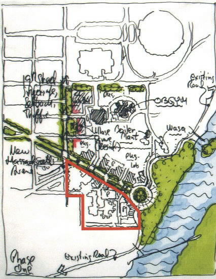
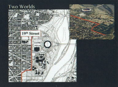
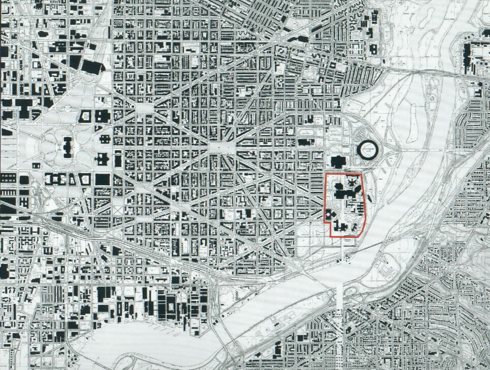
Public Reservation 13 lies on the eastern fringe of the Hill East neighborhood on the west bank of the Anacostia River. From the time of the origin of the L'Enfant Plan to today, the area has appeared as an isolated campus, separate and apart from the neighborhood and an obstacle between residents and their waterfront. This plan presents the first opportunity to re-envision the site, not as a Reservation but as a beautiful public place that links the existing neighborhood to the waterfront while also meeting District-wide and neighborhood needs for health care, recreation, civic space, and housing. The plan creates a new identity for the site.
This vision was achieved through the input and cooperation of many different stakeholders. District Agencies, including the Department of Health and the Department of Corrections, came together under the leadership of the City Administrator and the Office of Planning. Stakeholders adjacent to the site including neighborhood residents, the Sports and Entertainment Commission, and the Congressional Cemetery together with additional DC Agencies constituted the project Steering Committee that guided decisions and evaluated the planning process.
A series of four public meetings and a three-day intensive planning workshop were held to gather public input that led to the guiding principles that will direct the implementation of the plan in the years to come. Over people from across the city participated in these community-planning opportunities. Though there was not consensus on all issues, nine core principles emerged for the site:
Connect and integrate Reservation 13 with adjacent neighborhoods, and the new waterfront park along the Anacostia River;
Utilize the site to meet a diversity of public needs including health care, education, employment, government services and administration, recreation and housing.
Extend the existing pattern of local streets to and through the site to create simple, well-organized city blocks and appropriately-scaled development;
Maintain a human-scale of building heights that match existing neighborhood buildings and increase in height as the site slopes downward to the Anacostia waterfront;
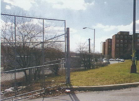 Figure 5 - Fences and parking lots on site near Building 25 and Anacostia River |
 Figure 6 - Aerial view looking toward the Anacostia River from the DC Jail |
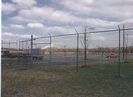 Figure 7 - Parking lots and fences define the existing views |
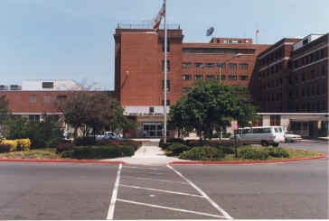
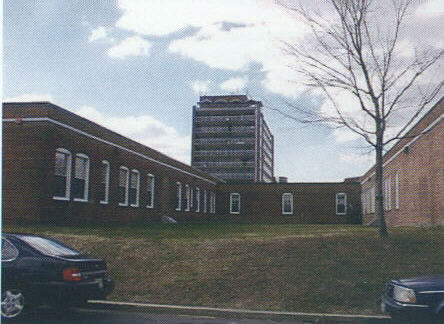 Figure 8 - Existing Department of Health Clinics at Reservation 13 |
This Draft Master Plan is only a first step. Detailed planning and design must still be conducted that incorporates site topography, environmental conditions, specific buildings and uses, and infrastructure needs. That planning process will again engage stakeholders, residents and neighbors. An interim use plan must also be completed to ensure that all active uses currently on the site are adequately accommodated and able to continue to deliver services to District residents while the first phase of the plan is implemented. The zoning process will provide the vehicle to legally define permitted uses and corresponding public hearings must be held to approve proposed zoning. Finally, there are significant budgetary and policy commitments that must be made to achieve this vision.
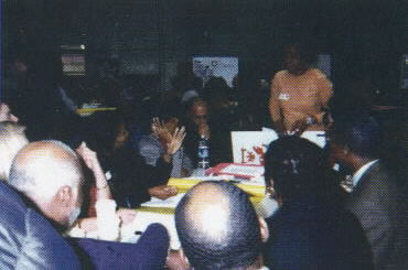 Figure 9 - March 2, 2002 - Community Workshop |
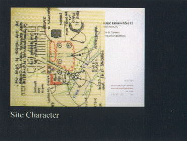 Figure 10 - Schematic Drawing from Community Workshop on March 2, 2002 |
The Budget Act of 2002 passed by DC City Council required that a Draft Master Plan be completed for Public Reservation 13. This plan was required before any Capital Improvement funds could be expended for DC General or for improvements to DC Jail facilities. The U.S. Congress approved the budget and the planning requirement and added a mandate that the plan be completed by March 31, 2002.
This planning effort constituted the first time in the history of this site that a plan was created with community input and participation. Though completed in a highly compressed and aggressive timeline, significant opportunities for public input and review were included. Public input contributed to the evolution of the plan and was essential in adjusting the plan to make sure sufficient land resources are available for various needs and uses anticipated by community members.
Three public meetings, an intensive 3-day planning workshop, and a weekend review session were offered for community participation. Meetings were held both on weeknights and weekends to provide the maximum opportunity for the majority of interested citizens to attend one or more session(s) depending on their daily schedules.
Over 300 people participated representing a broad range of stakeholders. Many participants were immediate neighbors to the site living on Massachusetts Avenue, Bay or Burke Streets. A good majority came from other parts of the Hill East neighborhood or Capitol Hill. Other participants were drawn from across the city, but active in health care advocacy. Nearly one quarter of participants attended every meeting offered - over a 20 hour commitment each!
The first meeting was held the evening of Wednesday, January 23 at the DC Armory. Nearly 200 people attended this first meeting. The purpose of the meeting was to establish the planning process and timeline, introduce the team, and outline the end products of the Draft Master Plan.
A second meeting was held the evening of Wednesday, February 20 at the DC Armory. This meeting provided participants with the critical background information and existing site conditions they needed to know to prepare for the planning workshop.
A 3-day participatory planning workshop was held over the weekend of March 1-3. The workshop began with a guided site tour of Reservation 13 on Friday, March 1. Saturday March 2 was an all day work session where participants worked in small groups concentrating on different issues that had to be addressed in the Draft Master Plan. These topics included transportation, parkland and public space, site character, general land uses, and defining the health care needs for the site. Groups worked on draft site plans to illustrate their priorities for the site. Sunday, March 3, project consultants condensed citizen and government input and outlined a set of principles that would guide future reuse of the site.
The morning of Saturday, March 16, a follow-up public review session was held to introduce the Illustrative Site Plan that evolved from the Guiding Principles and to obtain public reactions to the draft of the final product.
The final Draft Master Plan was presented at a final public meeting on the evening of March 20th. This meeting went over the complete process, the guiding principles, and the Illustrative Plan. The purpose of the meeting was to clarify the plan and answer questions about the next steps in the planning process after completion of the Draft Plan.
Outreach was conducted through a variety of methods. The Office of Cable Television and Telecommunications - the public cable channel - covered every meeting and workshop in February and March. Notice of meetings were out by mail, email, fax, and phone. Fliers were distributed door to door and at community meetings. Announcements for major meetings were published in Washington Post articles.
A public website was established to increase community access to information on the site and the planning process. In addition, binders of all background information, notes from meetings, community comments, and site maps were available for those without Internet access to review current information. These were located near the site at Eastern High School and at the MLK Central Public Library in downtown. Information was updated regularly. The website address is located at: http://www.publicspace.justicesustainability.com.
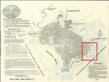 Figure 11 - L'Enfant Plan of Washington, ca. 1790 |
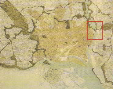 Figure 12 - McMillan Plan of Washington, ca. 1902 |
In 1848 the 30th Congress authorized the Commissioner of Public Buildings to transfer "such portion of the public reservation of land in the City of Washington, numbered thirteen, called the Hospital Square," to the vestry to extend the parish burial grounds (citation omitted). History texts from the period indicate that the Washington Asylum, previously known as "the workhouse and alms house," relocated from Judiciary Square to Reservation 13 between 1843 and 1846. Thus presumably, the reference to "Hospital Square" in plans from 1848. A January 20, 1877 Act mentions the Washington Asylum in Reservation 13 with reference to the construction of workhouses for the use of the District in connection with the Asylum upon "the public reservation in said City of Washington now occupied in part by the buildings of the Washington Asylum," designating the grounds south of the Asylum along 19th Street for new workhouses.
The Senate Park Commission Plan of 1901-1902 (commonly called the "McMillan Plan") proposed a new park system for the city, including the creation of the National Mall. The plan depicts a number of larger, isolated uses relegated to the peripheries of the original L'Enfant plan boundaries, including what eventually became Gallaudet College, and a site for a U.S. US Soldiers Home. In that plan, Public Reservation 13 is identified as the "City Farm". Massachusetts Avenue is shown crossing Reservation 13 and continuing to the other side of the river via a new bridge. At that time, this location was identified by the planners as a point where the character of Anacostia River landscape changes from an urban waterfront to a natural 'aquatic garden' or tidal marshland. The bridge helped to mark this transition.
The main buildings of DC General Hospital were constructed in the 1930's and 1940's. Additional buildings were added over time, growing to a complex of about 1,416,696 gsf for hospital and health related uses. The new Central Detention Facility (the DC Jail); constructed in 1976 replaced the Old Jail which dated from the 1870's and was located at the corner of Independence Avenue and 19th Street. A new Correctional Treatment Facility was added on the site to the southeast of the DC Jail which now has a combined total of 860,229 gsf.
|
|
Public Reservation 13 is located at the edge of the original l'Enfant Plan for the city. It sits between the orthagonal street plan of the largely residential Hill East neighborhood and the Anacostia River to the east. Two of the diagonal streets of the earliest plans of the city terminate on the site: Potomac Avenue and Massachusetts Avenue. The rest of the local streets bordering the site are 19th Street, running one way north, and Bay, Burke and C Streets SE running two-way in an east- est direction. Bay and Burke are truly local streets in that they extend only one block whereas C Street runs the length, albeit indirectly, of Capitol Hill and is from the earliest plans of the city.
The adjacent Hill East neighborhood is largely comprised of rowhouses with generous front yard set-backs and alleys to the rear.
Independence Avenue stretches from the northern edge of the Reservation all the way to the National Mall and on toward the Potomac River. It carries a large portion of commuter traffic and runs one way from west to east. It also is a major access to parking lots at RFK Stadium for sporting events.
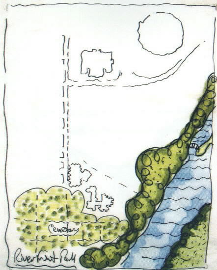
To the south of the site is the historic Congressional Cemetery. Across the river is Anacostia Park, the continuation of Massachusetts Avenue and Fort Dupont Park, as well as a locomotive bridge that crosses the river and continues through the park to the northeast.
The regional traffic arteries of Interstates 295 and 395 are close to the site and the network of roads facilitates connection to these highways.
Kingman Island, one of the islands in the center of the Anacostia River, is just beyond the adjacent shoreline near the Reservation.
|
|
Public Reservation 13 is directly related to two ongoing planning efforts — the Anacostia Waterfront Initiative (AWI) and the Neighborhood Planning Initiative (NPI).
As part of the Mayor's Neighborhood Action Initiative, Strategic Neighborhood Action Plans (SNAPs) were completed for every neighborhood in the District of Columbia. These plans were created by neighborhood residents during the Spring and Summer of 2001. The SNAPs outlined the essential ingredients of a thriving neighborhood and identified the top priorities for improving the livability of their own community. Public Reservation 13 was included in the SNAP of the neighborhoods of Hill East, Capitol Hill and Lincoln Park. The top priorities for this area included:
Neighborhood
Economic Development
Neighborhood residents
wanted to see better retail, commercial, and employment opportunities in
their neighborhoods. They stressed the importance of utilizing transit
stations in accomplishing this goal.
Transportation
Solutions
The neighborhoods have
substantial concerns relating to commuter traffic and tour buses on
residential streets, insufficient and unsafe bicycle and pedestrian ways,
and severely constrained parking. They advised that future planning
accommodate these needs and begin to address and correct transportation
issues.
Recreation,
Education and Amenities
Open space amenities in the
neighborhoods are insufficient. Though residents live close to the
Anacostia River, the river remains physically inaccessible and unsafe for
public use. Metro plazas too represent underutilized and poorly designed
public space. Residents want signature parks and plazas that offer usable
opportunities for recreation and relaxation.
Housing and
Historic Preservation
Maintaining housing
affordability - particularly for seniors and low-income families - was a
top concern, as was the preservation of the historic character of the area.
Appropriate Design
and Development
Perhaps more than any other
priority, residents were concerned about the impact of future development
in their neighborhoods. Two questions in particular worried area residents
- what would happen to the land once occupied by DC General and how could
development make the most of the three Metro stations? Residents felt it
was imperative for the District to complete a Master Plan for the DC
General site to make sure that the land was not allocated solely to locally
undesirable land uses (LULUs). Similarly residents
recognized that their Metro stations could draw positive develop but only
if plans were completed that could catalyze the potential of then
resources.
 Figure 15 - AWI Study Area |
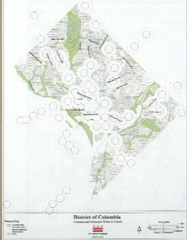 Figure 16 - TOD locations in Washington, DC |
The primary objective of the Anacostia Waterfront Initiative is to improve the environment around the waterfront to highlight the Anacostia River as a key natural and community resource of the District of Columbia. The project area encompasses the whole of the Anacostia Waterfront from the DC/ Maryland border to the confluence of the Potomac River - including the Washington Channel in Southwest.
The Anacostia Waterfront Initiative is a common partnership of Federal, District, neighborhood, and non-profit stakeholders to create a vision for waterfront areas along the Anacostia River. Building on the great historic plans for the District of Columbia, the partnership envisions a new, energized waterfront for the new millennium that will unify diverse areas of the District of Columbia by capitalizing on one of the City's greatest natural assets, the Anacostia River shoreline. The Waterfront Initiative seeks to revitalize surrounding neighborhoods, enhance and protect park areas, improve quality of water and environment, develop Government-owned land for the benefit of the people of the District of Columbia and the Federal and District of Columbia Governments, and increase access to the water and enhance activities provided along the waterfront.
The Anacostia Waterfront Initiative has seven overarching planning principles:
Reservation 13 represents .an immediate opportunity to initiate the AWI through the creation of a critical segment of a great park system along the Anacostia River.
In fall of 2001, the Mayor convened a Task Force to define what Transit-Oriented Development (TOD) might mean for the District of Columbia and how our transit resources - both bus and rail - could be used to improve the quality of our neighborhoods, spur economic development, and help the smart growth of our city.
The Task Force defined TOD in the District of Columbia as "a land use strategy to accommodate new growth, strengthen neighborhoods, and expand choices and opportunities by capitalizing on bus and rail assets to stimulate and support vibrant, compact, diverse and accessible neighborhood centers within an easy walk of transit."
The Task Force found that TOD is one of the most effective tools available to Washington, D.C. to help realize its vision as one of the premier places the world to live, learn, work and visit. The District's 39 Metro stations and major bus corridors offer the potential to accommodate both new and current residents in attractive, walkable, mixed-use neighborhoods offering a range of housing choices within a 10-minute walk of high-quality transit. The transit resources provide a unique opportunity to form vibrant neighborhood centers that are linked to opportunities and activities throughout the District and region.
Recent estimates indicate there are over 2,000 acres of vacant, abandoned, or underutilized land within a 10 minute walk of these stations or major bus corridors that could potentially accommodate over 35,000 new units of housing along with shops, offices, parks, and other amenities.
As a result of the Task Force's work, and in response to a grassroots groundswell in support of better utilizing transit resources to both support economic development and protect environmental quality, the District is establishing a policy to support TOD as a land use and growth strategy for the District of Columbia.
Reservation 13 is served by two underutilized Metro stations at Stadium/Armory. These represent opportunities to promote TOD and make the site more attractive for future development.
 Figure 17 - Plan of existing buildings at Reservation 13 |
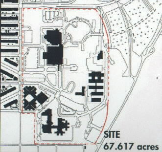 Figure 18 - Active uses on Reservation 13 |
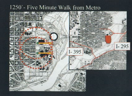 Figure 19 - Walking distance to Metro and access to regional highway network |
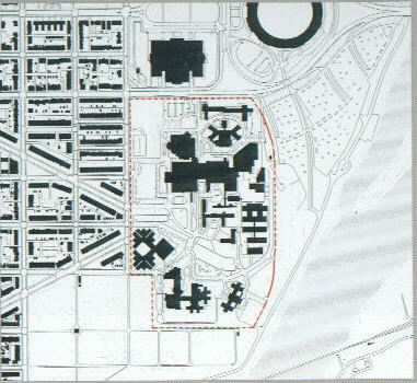
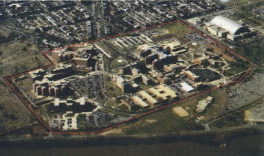
Public Reservation 13 is a campus setting with large, sprawling buildings that serve DC General Hospital, the Jail and Correctional Treatment facility, the Department of Health clinics and services and the offices and work spaces of the Medical Examiner. Most of the hospital and health clinic buildings are located to the center of the site and are in general surrounded by large parking lots. Movement around the site is facilitated by a series of driveways with minimal connection to the street grid of Capitol Hill.
Entry to the campus is currently gained primarily from the intersection of Massachusetts Avenue and 19th Streets and from two smaller drives at Independence Avenue. Both of these are accessible to parking and services at the campus.
The site slopes toward the river basin, falling approximately forty feet from the boundary at 19th Street. In general, this affords excellent views of the river landscape and the river islands from 19th Street.
The site is also easily visible from the eastern side of the river, from River Terrace and Anacostia Park, and from the Whitney Young Bridge approaching the city from the east. Access to the regional road system is convenient as is access to the Stadium-Armory Metro station of the Blue and Orange line located on site.
The site is characterized by four distinctly different areas at its edges: Sports and Recreation around RFK Stadium to the north; the residential areas of the Hill East neighborhood to the west; the historic Congressional Cemetery to the south; and, the Anacostia River waterfront to the east and southeast.
The Department of Health operates health clinics for sexually transmitted diseases, a detoxification program, Women's Services, and Chest Clinic/TB Clinic (Buildings 8,12,13, and 15 respectively) at the eastern edge of the site in a series of one story buildings. Included in this area as well is the Department of Mental Health's program (Building 14) and Building 27, used by the Office of the Medical Examiner. A small service road passes in front of these structures and pedestrian access to this part of the facility is circuitous and difficult.
|
|
Kerrick Hall (Building 17) is currently used by a federal agency, Court Services and Offender Supevision Agency (CSOSA), as a residential treatment center for ex-offenders. CSOSA plans to expand its capacity on the site for treatment of up to 110 people in a 60,000 gsf facility. Building 25 is vacant and is located in a prime redevelopment area. It is also surrounded by parking lots.
Currently, the Correctional Treatment facility (Building 20) and the DC Jail (Building 28) are in full operation. Since the closing of DC General Hospital in 2001, the majority of the buildings that comprised the old hospital are either vacant or only partially occupied. Building 29, the Ambulatory Care Center and Emergency Care Center continues to provide sub-specialty clinics and emergency care services as part of the agreement between the City and the Health Care Alliance. The bulk of the old main hospital buildings, Buildings 2- 6, 9-11 and 16, are substantially vacant.
Reservation 13 enjoys excellent access to the Metro system and has a Blue and Orange line station at the edge of the site at C and 19th Streets SE. The other entry is located just west of the Armory.
The site developed over a long period of time and grew incrementally with buildings added as needs were identified. Buildings range in height from one to eight stories and are a collection of many architectural styles, from a traditional style of the original hospital buildings to recent, more modern interpretations.
The site presents itself today as a vast area of seemingly unrelated buildings associated only by proximity, their former use and little else. The vast areas of surface parking lots block access to the river and give the impression of a site devoted to parking. Few footpaths lead to any areas where the beauty of the natural environment can be appreciated. In fact, the closer one moves to the river, the larger the size of the parking lot to be negotiated. Department of Health services located along the site's eastern edge are among the most heavily used and are situated in the most remote and inaccessible location on the site. And, although Metro is nearby, few buildings are situated close to the station entrances.
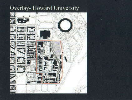
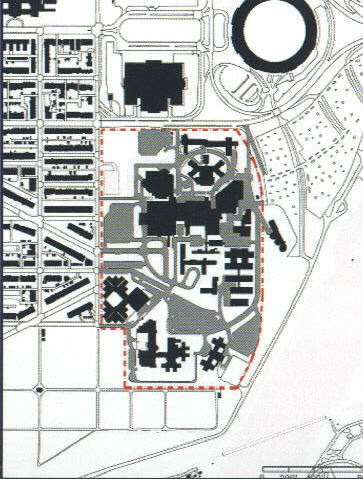
The 67 acre site is comparable in size to the main campus of Howard University. Scale comparisons also indicate that much of the historic district of Alexandria, Virginia is approximately the same size. The site is so large that a number of different uses scan be accommodated. For example, the current building in which the George Washington University Hospital is located could easily fit on the site.
The local landscape is characterized by large, stand-alone buildings, such as the Armory and RFK Stadium, which sit on vast sites adjacent to large parking lots. Many of the adjacent streets are designed for high- speed traffic. A soccer-friendly stadium of about 20,000 to 25,000 seats is in preliminary planning stages just east of the site in one of the parking lots for RFK Stadium. It is anticipated that this facility would be designed with one end open to the river and be a venue for outdoor concerts as well.
To the east is the natural landscape of the Anacostia River and Kingman and Heritage Islands and a section of RFK's parking lots. Also located just east of the site is a DC Water and Sewer Authority (DCWASA) pump station and swirl concentrator. This facility both treats effluent and pumps sewage across the river to the Blue Plains station. An existing traffic lane passes along the rivers edge and is used primarily for access to parking lots at RFK during events.
The site shares a southern edge with the historic Congressional Cemetery. That area is currently behind both correctional facilities and contains a secure sally-port for each:
To the west, across 19th Street is the Hill East neighborhood, a residential district comprised mostly of row houses and gridded streets of the historic C Enfant plan. The most prominent of these streets is Massachusetts Avenue, a street dating from the original plan of the city. Massachusetts Avenue stretches from upper Northwest to the edge of Reservation 13, passing through some of the most significant neighborhoods and landmarks of Washington.
|
|
No complete environmental assessment of the site has yet been performed. The Department of Corrections has an ongoing remediation effort on the site resulting from the removal of underground storage tanks containing gas and diesel fuel. Tests have been performed at locations throughout the site to monitor the extent of contamination. Work continues to remove petroleum products from the soil.
Other underground storage tanks are known to be located on the site and pose concerns. Future analysis and remediation efforts should address these conditions.
The site also has extensive amounts of storm water runoff into the river after heavy rainfall. This results in contaminants entering the soil, the river and adjacent landscape. This is also exacerbated by the slope of the site toward the river and the vast amounts of surface parking.
Many of the existing buildings on the site have other environmental issues as well. Asbestos was used in the construction of many of the older buildings and remediation would be necessary to remove its potentially harmful effects.
In summary, environmental improvements to the site and buildings represent one of the most important challenges in the future and offer a key opportunity for the introduction of sustainable building practices and the implementation of low impact development.
As part of the system of "Public Reservations" in the landmarked L'Enfant Plan for Washington, DC, the site is considered 'historic' and designated in its entirety as part of the city plan. This refers to the "Reservation" and not to individual buildings located on the site.
Further review will examine preservation issues regarding the transfer of the Reservation to the District as well as issues regarding the eligibility of any building in particular. At present none of the buildings are of landmark status and few are considered eligible for future designation.
No areas north of Massachusetts Avenue have been surveyed for archeological remains. Recent studies for the site south of Massachusetts have indicated the presence of prehistoric settlements in areas where the current Jail and Correctional Treatment Facility are located. A site designated "Reservation 13 Archeology Site" of these pre-historic settlements and graves is located to the south side of Building 25. These discoveries offer opportunities to understand the size and character of these settlements and may help to guide thinking about future monuments or attractions on the site. The future of these discoveries and the extent to which they will be further studied and/ or preserved must be incorporated in future detailed planning for the site.
Because of the unified institutional nature of the site, all buildings are served by a single steam heat system. This system of steam heat and associated tunnels is in need of major improvements and extends throughout the site from Building 7, the existing Boiler Plant. These tunnels provide steam heat to all buildings on the site. Buildings have individual systems for air conditioning.
Subsurface sewer and storm water systems include several large combined sewer pipes in the area. For more information on the sewer system, please refer to DCWASA's recently completed long-term control plan.
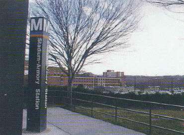 Figure 22 - Site Photo, Stadium-Armory Metro Station - Note the distance to existing facilities |
 Figure 23 - Site Photo, an existing view at the waterfront - A large amount of the site is dedicated to impervious surface |
This planning process was initiated to evaluate and resolve a number of factors that currently limit the opportunity of the site to be a strong public resource that contributes to the health and vitality of the District, our neighborhoods and waterfront.
This plan attempts to solve for these conditions and thus realize the tremendous potential of this site.
The opportunity presented by a new plan for Reservation 13 is unique in the history of Washington, DC. Since inception, the site has been detached and apart from the regular fabric and neighborhoods of the city. This condition has also been contributed to by the uses present today on the site- corrections and other health- related services, historically isolated, like in many other cities.
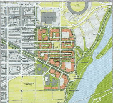
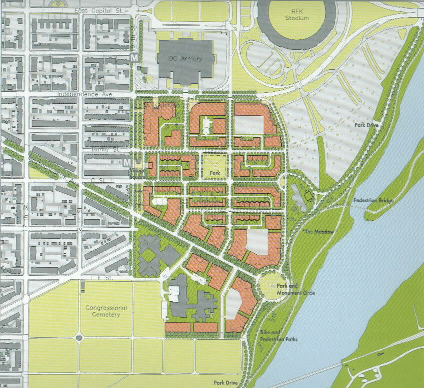
The Draft Master Plan envisions a paradigm shift from an isolated campus to a new waterfront neighborhood. The plan proposes rebuilding the existing uses on the site today and adding a new mixed- use dimension which over time will add a critical mass of density to support a variety of new uses and activities. The new Hill East Waterfront neighborhood will be safe, connected to the rest of the city, and home to new state- of - the art buildings for city services. The introduction of new streets and city blocks will overcome this historic isolation and offer a mix of uses and public parks. Unlike the current situation, new building activity will concentrate closer to the Metro station and take advantage of new building sites defining the termination of Massachusetts Avenue at the water. Taken together, these elements establish a new place in the city with access to the natural environment and connection to the nearby neighborhoods.
With the existing buildings of the DC Jail and Correctional Treatment Facility remaining in place, over forty of the sixty-seven acres on the site are available for redevelopment consideration. To avoid the mistakes of the past and to make a truly vibrant waterfront neighborhood, the plan includes a mix of uses. Over time this will include new facilities for city-wide health uses, services and offices, residential buildings, municipal offices, and sites for city and regional institutional, health-care and recreational uses. Residents on the site are an essential component of the plan because they bring a secure presence to the neighborhood and help to end the isolation of the single- use area. Such diversity of use - while maintaining the primary focus on health care and corrections - will assure that the site trades its current isolated appearance and use in for a new balance of uses spread throughout the day in a new network of urban spaces, public parks and local streets.
|
|
2. Utilize the site to meet a diversity of public needs including health care, education, employment, government services and administration, recreation and housing.
3. Extend the existing pattern of local streets to and through the site to create simple, well-organized city blocks and appropriately-scaled development;
4. Maintain a human-scale of building heights that match existing neighborhood buildings and increase in height as the site slopes downward to the Anacostia waterfront;
5. Connect the Hill East neighborhood and the city at large to the waterfront via tree-lined public streets, recreational trails and increased access to waterfront parklands;
6. Demonstrate environmental stewardship through environmentally sensitive design, ample open spaces, and a great waterfront park that serve as public amenities and benefit the neighborhood and the city;
7. Promote the use of mass transit by introducing new uses near Metro stations and create an environment where the pedestrian, bicycle, and auto are all welcome, complementary, and unobtrusive, reducing the impact of traffic on adjacent neighborhood streets.
8. Create attractive "places" of unique and complementary character including:
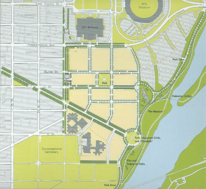
 Waterfront Park Connect and integrate Reservation 13 with adjacent neighborhoods and the new waterfront park along the Anacostia River. Create a great park along the Anacostia River accessible by all. Call this park "The Meadows". |
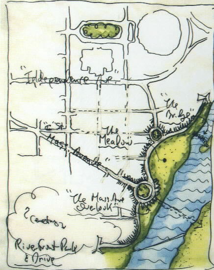 Waterfront Park & Park Drive Upgrade the existing RFK access drive into a park drive from low-speed automobile movement (that is not a commuter cut-thru) to facilitate local movement and access to the Anacostia Riverwalk and Trail (pedestrian and bicycle) and to the parking lots at RFK Stadium. Use the new Park Drive for access by police and emergency vehicles. |
 Four Districts Utilize the site to meet a diversity of public needs including health-care, research, education, employment, government services and administration, recreation and housing.
|
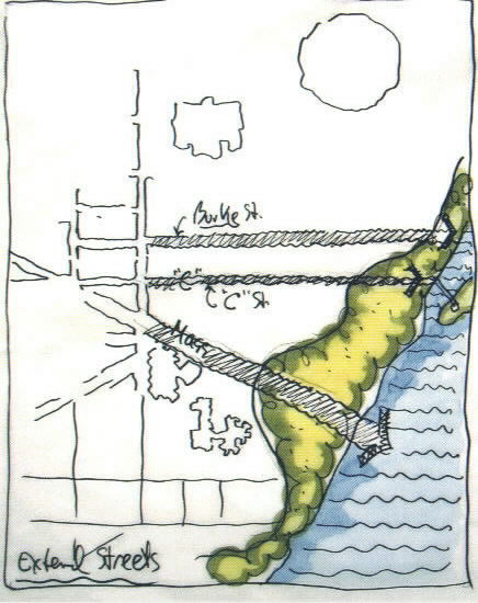 Extend Streets Extend the existing pattern of local streets to and through the site to create simple, well-organized city blocks, appropriately scaled development, and views to the waterfront. |
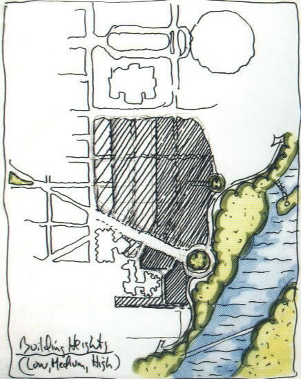 Building Heights Maintain a human-scale of building heights that relate to the existing residential buildings on 19th Street and increase in size as the site slopes down towards the waterfront. |
 Open Space System Connect the Hill East neighborhood and the city at large to the waterfront via tree-lined streets, recreational trails and increased access to waterfront parklands. |
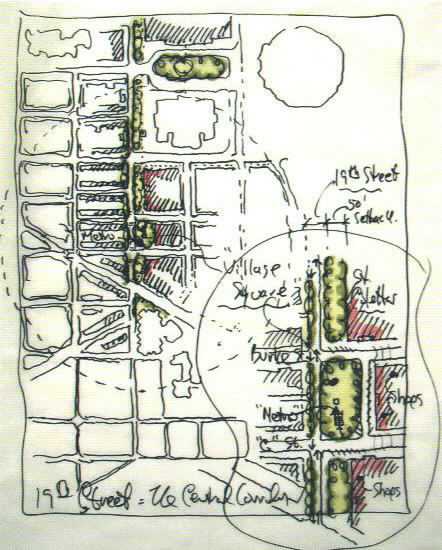 Promote Mass Transit/Village Square at 19th and C Streets Promote the use of mass transit by introducing new uses near Metro stations and create an environment where the pedestrian, bicycle, and auto are all welcome, complementary, and unobtrusive, reducing the impact of traffic on adjacent neighborhood streets. |
 Places Create attractive "Places" of unique and complementary character including:
|
 Correctional Facilities Limit improvements to correctional facilities to areas south of Massachusetts Avenue. |
|
|
The plan illustrated here features:
This version of the Draft Master Plan shows a maximum build-out and includes 3.2 million gsf for health care uses, clinics and offices, approximately 800 residential dwelling units and 35,200 gsf for retail construction. It approximately doubles the current amount of gross square feet built on the site. Future planning and building design will determine the actual amount of space to be constructed on the site.
|
|
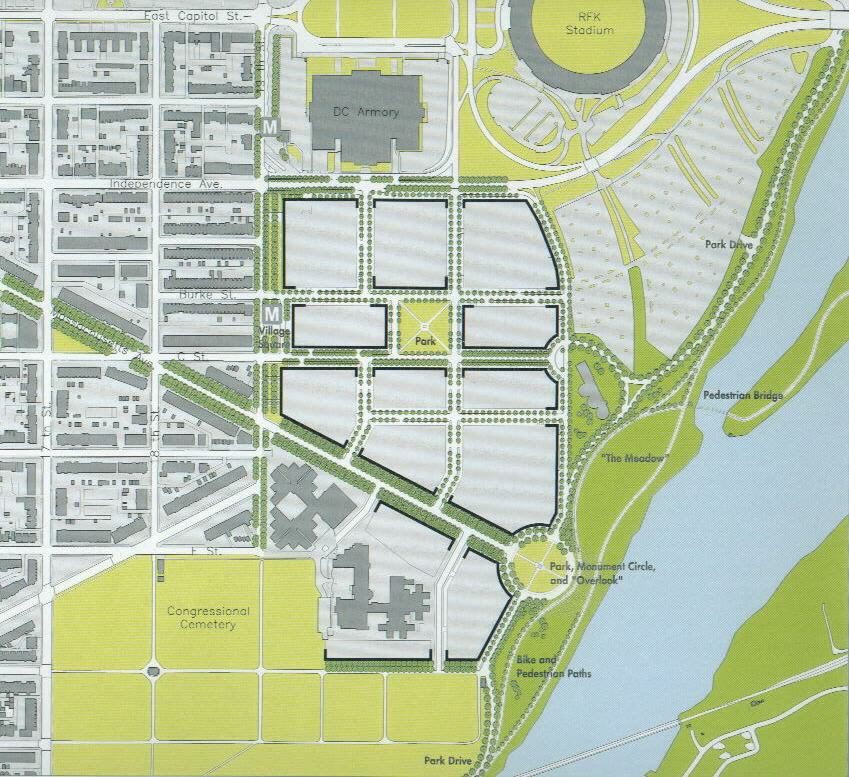
The Draft Master Plan enhances and accommodates future transportation needs by providing an integrated street network with many connections to existing streets. The grid replicates the existing pattern of streets, blocks and public squares that make Washington, in general, and Hill East in particular, so successful as urban neighborhoods. It offers multi- modal opportunities by providing sites for development at Metro stations. Parking is accommodated in garages throughout the site, reducing the need for surface parking lots and providing an environment at street level for both the pedestrian and the automobile. Specific recommendations include:
|
|
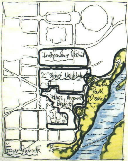
The Draft Master Plan is comprised of four districts: Independence Avenue District, C Street Neighborhood, Massachusetts Avenue District and the Waterfront District. Each district is different in character and use and serves a different need. The variety of districts in the plan help relate the plan to the very diverse areas surrounding the site area and establish diversity within the plan itself. The uses of the districts are:
|
|
Independence Avenue District
City Wide Uses and Services
Health Services
Recreation
Education
C Street Neighborhood
Residential
Health Services
Community Amenities
Neighborhood Retail
Waterfront District
National Park Service Parkland
|
|
The site slopes down to the river (45' total) and provides the opportunity to develop great variety in the heights of buildings and the overall skyline. In general building heights will increase towards the water, although the apparent height of the buildings from the Hill East neighborhood will be diminished because of that slope. Building sites closest to 19th Street SE will approximately match the townhouse neighborhoods to the west in two to four story heights. The central section of the plan will be heights of four to seven floors with the tallest buildings reserved for the sites closest to the waterfront and the lower end of the Massachusetts Avenue District.
The heights are a range of heights in the area and the plan provides for a roofscape of great variety and interest.
Range of Building Heights2-4 Story Buildings
4-7 Story Buildings
7-10 Story Building
|
|
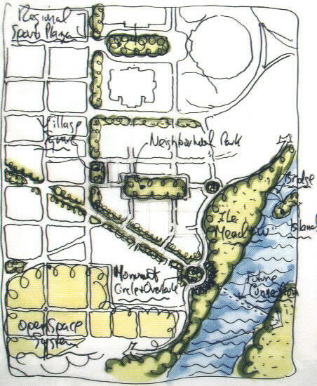
The Draft Master Plan includes many public open spaces and public parks.
Since the Senate Park Commission Plan of 1902, Washington, DC has been graced by a grand park network of public green spaces large and small. The Anacostia Waterfront Initiative sees the enhancement of these public spaces as vital to the future of the city. Parks developed in this plan total approximately fifteen acres of new park space and range from neighborhood scale to a waterfront park that ties into the large network of parks and green spaces throughout the city.
The introduction of parks, some on National Park Service land at the waterfront, serves to provide passive and active recreation spaces in a area of the city with minimal parkland. New parks can also help to minimize the harmful effects of runoff and provide environmental
Set-back lines in the Draft Master Plan are also conceived to continue current set-backs in the adjacent Hill East neighborhood. These set-backs allow for the development of green 'front-yard' spaces and greatly increase the amount of landscaped space in the new plan.
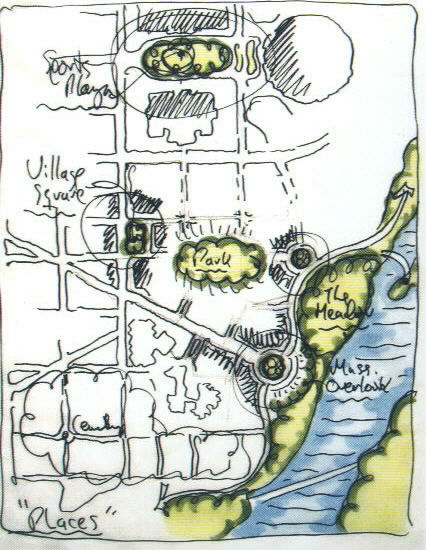
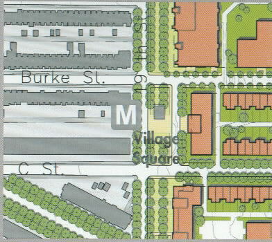 Village Square |
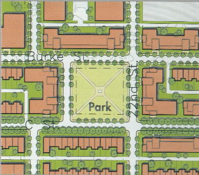 The Park |
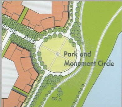 Monument Circle and the Overlook |
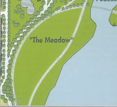 The Meadow |
Places in the Draft Master Plan help to give identity, character and variety to the plan and a sense of how one place will be different from another. Each of the Places in the Draft Master Plan are conceived to be different and to help give variety to the neighborhood as well as contribute to orientation and way finding throughout the City. All of the Places in the plan support the overall vision and also address specific needs for open space of character and distinction.
Places in the plan include:
The Village Square: The Square is a mixed-use center with neighborhood-scale retail at ground level with residential units above. The square is a vibrant place and is located at the center of the existing Hill East neighborhood and the new Hill East Waterfront. It is at the location of one entry to the Armory-RFK Stadium Metro stop
The Park: The Park is a smaller version of the lush, green, neighborhood squares of Capitol Hill such as Stanton Park or Lincoln Park. It is tree-filled and primarily residential in character.
Park, Monument Circle and the Overlook These spaces provide an appropriate termination to Massachusetts Avenue, a significant location to view the river, and connect the tree-lined streets of the neighborhood to the Park Drive and the meadow on the new waterfront.
The Meadow: The Meadow is a new waterfront park focused on the river and a place of both active and passive recreational activity. The Meadow embraces the river and provides much needed park space to the neighborhoods and the city. The place is also part of the system of open spaces and parklands along the banks of the Anacostia River.
The Draft Master Plan is just that: a draft. For the vision to be implemented and for Reservation 13 to play a more important and central role in the life of the District, additional study will be necessary to translate the recommendations of this document into public policy and agency actions. The following actions are necessary for this to occur:
The process of adopting this Draft Master Plan will require the following actions:
DC COUNCIL VOTE OF APPROVAL JURISDICTION OF RESERVATION 13
In March 2002, the DC Council voted to accept the Transfer of Jurisdiction
from United States of America to the District of Columbia. This vote
allows the current owner of the land, the General Services Administration
to proceed with the Transfer of Jurisdiction by gaining the approval of
the National Capital Planning Commission.
SUBMITTAL OF DRAFT MASTER PLAN TO DC COUNCIL
This plan will be submitted to the DC Council by March 31, 2002.
NCPC APPROVAL OF TRANSFER OF JURISDICTION
Reservation 13 is owned by the United States and is controlled by the
General Services Administration (GSA). All planning and development
actions are currently reviewed by the National Capital Planning Commission
(NCPC) and are not subject to the District of Columbia's jurisdiction. The
GSA seeks to transfer the jurisdiction of the property to the District of
Columbia, an action which must be approved by the NCPC. Estimated time of
completion: May/June 2002.
Upon transfer to the District of Columbia, the Office of Planning will initiate a zoning case of the site with the District of Columbia Zoning Commission. This case will propose the specific zoning policy which meets the land use goals an( criteria established in the Draft Master Plan document. The report for the zoning case to the Zoning Commission will develop and refine the recommendations of this Draft Plan to result in the specific language of the zoning text as well as a set of complementary Building Design Guidelines to guide the architectural design of buildings and landscape elements on the site. Estimated time of completion: December 2002.
Upon transfer, the Office of Planning in collaboration with the Office of the Surveyor and the District Department of Transportation will initiate the proposed mapping of the streets on the site. It is likely that a detailed traffic analysis will be completed as a component of the street mapping which will include traffic recommendations to streets adjacent to the site. (Please note that Massachusetts Avenue is already mapped as a street). This process will include detailed survey information and will require preliminary site engineering in order to establish site grading benchmarks and to accurately map proposed streets. The DC Council is required to vote and approve the proposed street mapping. Estimated time of completion: September 2002.
Ongoing preparation of agency budgets for capital improvement projects will determine which building sites will be constructed first.
|
|
The redevelopment of the site will take place over a period of years in a series of planned construction phases. Like the historic plan of the city, construction will occur over a long span of time as the vision becomes reality.
An Interim Plan will retain existing uses on the site by using some existing buildings on a temporary basis and relocating parking. Building 29, the Ambulatory and Critical Care Center will remain with its current services. Other clinics and services on the site may be relocated on the site on a temporary basis at a later time but will remain in operation throughout.The Phase One plan envisions the completion of the Park Drive and Waterfront Park, the buildings on either side of Massachusetts Avenue defining the Massachusetts Avenue District, and the 19th Street/ Village Square neighborhood of retail and residential uses. St. Coletta School will also be part of this first phase and is important to initiating the plan at the 19th Street edge of the site and the Village Square. CSOSA will expand its facility on an interim basis as part of Phase One. This phase will be coordinated with the National Park Service, which has jurisdiction over waterfront areas and new parks adjacent to the site.
The first phase will bring about an important first step in the transformation of the site. The designated sites are areas with little or no buildings. 19th Street and Massachusetts Avenue will assume a new character.
As the phased redevelopment of the site proceeds, it is imperative that no part of the site is both a construction site and a place where people are living and working.
All existing health care and correctional uses currently located on the site are to remain located on the site. No interim impacts, disruptions or interruptions are anticipated for any of the existing health care uses on the site, including the existing clinics, ambulatory care, and the Emergency Room at DC General. Correctional uses are to remain in facilities south of Massachusetts Avenue SE.
A number of buildings on the Reservation 13 site are in a poor state of repair and vacant. A detailed building conditions assessment must be prepared in order to assess where interim uses may be located in existing buildings. It is anticipated that the programming, design and construction of new facilities on the site will take at least 4 to 8 years. In the meantime, important decisions will need to be made to assess what uses can be accommodated on the site in an interim manner which is cost effective, consistent with the objectives of the overall plan and which can be easily implemented.
PUBLIC HEALTH AND SCIENCES CENTER
The City is in the early stages of planning for a new facility to house a
number of public health and science related functions, including labs,
clinics and associated offices. These uses either already exist on the
site and are currently housed in deteriorating buildings, or are located
in disparate facilities throughout the District. The facility is
envisioned to consolidate these functions into a single, user-friendly
facility. At this time, it is envisioned that this facility could initiate
the construction of the Massachusetts Avenue District and play a major
contributing role in establishing the extension of Massachusetts Avenue to
the waterfront.
COURT SERVICES AND OFFENDERS SUPERVISION AGENCY (CSOSA)
The CSOSA maintains a secure treatment facility for ex-offenders on the
site, currently in Karrick Hall (Building 17). The use will remain on the
site for both short-term and long-term timeframes. It is necessary to
identify one of the existing buildings on the site to house this use in
the interim, and it is anticipated that a new facility will be
constructed, potentially as a component of a Public Health and Sciences
Center. Important considerations must be evaluated with regard to the
interim location of CSOSA. The interim location must be functional and
cost effective for the agency, but it must not be located where it
prohibits the rational implementation of specific plan elements. It is
anticipated that the interim location will continue operations while the
permanent facility is designed and constructed on a site in the
Massachusetts Avenue District.
ST COLETTA SCHOOL
St. Coletta School is an independent, non-sectarian and nonprofit
institution for children ages four through twenty-two with moderate to
severe mental retardation, autism and secondary disabilities. The goal of
St. Coletta School is to provide a program that meets the specific needs
of each student. Students come from the entire metropolitan Washington,
D.C. area.
St. Coletta School has received federal appropriations to relocate to the District and has coordinated with the General Services Administration and the District of Columbia to locate on the Reservation 13 site, at the corner of Independence Avenue and 19th Street SE. The proposed school facility will require less than 4-acres of land and has been incorporated into the Draft Master Plan by establishing a site area bounded by Independence, 19th Street, the proposed extension of 20th Street and the proposed extension of Burke Street SE. The St. Coletta School location in the "Independence Avenue District" of the Draft Master Plan is consistent with the city-wide services function of this district as well as the residential scale and character proposed along 19th Street.
| Date | Activity | Purpose |
| January 23, 2002 | Project Commencement Meeting | Present an overview of the Draft Master Plan Project and to solicit the community's comments on the Plan. |
| February 5, 2002 | Local Neighborhood Meeting | Requested by citizens, a small group meeting to review the Draft Master Plan project. |
| February 20, 2002 | Existing Conditions and Background Info Mtg. | Provide details on the progress of the draft master plan and to prepare the community for the upcoming Workshop. |
| February 21, 2002 | Located Notebooks at Eastern High School, MLK. Library and Office of Planning | Provide public with hard copy information on Reservation 13 planning process |
| February 25, 2002 | Launched website | Provide web based vehicle for informing and educating public about Reservation 13 at www.pubIicspace.justicesustainabiIity.com |
| March 1-3, 2002 | Community Planning Workshop | Site Tour and to have community members work side-by-side with the architects and city planners to create a working draft of the vision for the site - what its purpose should be; and to establish a set of guiding principles for the development of the site. |
| March 16, 2002 | Open House | Provide the latest draft and solicit the community's feedback. |
| March 20, 2002 | Final Public Presentation | Present the Draft Master Plan that will be given to the City Council. |
|
|
This section outlines the general themes of comments provided by residents, stakeholders, and participants. Input was gathered not only at the organized public meetings, but also via telephone calls, letters, emails, and on Internet discussion groups. A wealth of information, comments, and perspectives was submitted during this process. The level of community comment was more detailed and extensive than what is provided here. This section captures the general themes of discussion and does not represent the full public record, a consensus opinion or prioritization of opinions expressed at the community meetings. Moreover, the following opinions are not representative of a thorough or scientific sampling of community opinion, but rather represent only the opinions of those who attended the workshop and meetings. This section is not intended to provide a rebuttal to the many diverse concerns or opinions that are recorded here.
Common Community Concerns
Over the 10-week planning process, three primary concerns emerged time and again for various participant groups in the planning process.
January 23, 2002 - 6:30 pm - 8:30 pm
Project Commencement Meeting
(Location: DC Armory)
227 participants attended the first public meeting. Participants included roughly equal proportions of health care advocates, local neighborhood residents, and other District stakeholders. Primary comments focused on the short and/or limited notice of the public meeting, concerns over the closing of DC General hospital, and skepticism about the commitment to true community engagement in the process.
The meeting began with a brief overview of the Draft Master Plan Process, its purpose, components, and the proposed timeline for completing the planning process. Open public comment followed. Several main themes emerged including recommended uses, ideas to maximize citizen engagement, and comments regarding DC General and correctional facilities on the site.
Theme 1: Community Engagement Process
Citizens wanted to ensure that this process was as open and participatory
as possible and that the time and commitment of the citizens was valued.
Specific, actionable suggestions were to 1) have Channel 16 present at all
meetings, 2) announce meeting dates/times well in advance, and 3) plan
workshops on different days/times - some weeknights, some weekends.
Citizens commented that it was important not only to have the community involved, but to have many diverse views at these meetings. Some people expressed skepticism about the process and wanted assurances that the plan was not already "a done deal" and that community concerns would be heard. Specific comments included:
Theme 2: Ideas for the Site
Several participants volunteered recommendations for utilizing the site
for the benefit of the neighborhood and the District. This list included:
Theme 3: Current uses - DC General and Correctional Facilities
Some speakers stated that they were concerned about the closure of DC
General Hospital and its impact on health care and were interested in a
full-service, state-of-the-art hospital with a trauma one center.
Additionally, the community had questions on the status and expansion of
the correctional facilities on the site.
Other individuals had questions relating to land use and the full planning process - both in this Draft Master Planning effort and beyond - to plan implementation, zoning, legal interpretations, and development. Residents were concerned about zoning and the protections it might offer to the community. The presentation stated that the transfer of jurisdiction was conditioned on the site being used for "any municipal purpose." This phrase was ambiguous to many participants and did not indicate which uses might be permitted or prohibited under this condition.
Regarding the process, participants wanted planners to provide an opportunity to have a working tour of the site to become familiar with it before planning workshops. Other participants requested that information on the site, including past plans, studies, and resources be made available
February 20, 2002 - 6:30 pm - 8:30 pm
Existing Conditions and Background Information Meeting
(Location: DC Armory)
81 participants attended the second public meeting - 20 were new to the process having not attended the first meeting. The meeting began with an open house-type small group session. Maps were provided depicting the site in its regional context, the site surrounded by diverse bordering uses, existing conditions on the site (both maps and photos), and scale comparisons of the site to other familiar areas in the region (i.e. the main campus of Howard University, GW Hospital, Old Town Alexandria, etc.) Public comment was received in the small group discussions.
A presentation followed that provided baseline background information on the site, existing conditions and size comparisons for planning consideration. In addition, the consultant team indicated that some uses were to be considered "givens" during the planning process. These included: Accommodation of existing health care uses on the site in any new plans for the site; Preservation and containment of correctional uses on the site south of Massachusetts Avenue; Interim accommodation of CSOSA (Court Services and Offender Supervision Agency) on the site in a location to be determined through the planning process, and; Location of St. Coletta School on 4-acres on the site at the corner of Independence Avenue and 19th Street, SE.
Andrew Altman, Director of Planning, provided an overview of agenda and format for the intensive 3-day community planning charrette planned for the following weekend. He then closed the meeting.
Some participants expressed frustration that they were not able to provide comments in a large group setting at this meeting and felt the small group sessions at the beginning were inadequate forums in which to articulate their concerns. Following the meeting, other participants submitted comments to the Office of Planning indicating some skepticism about the level of community input in the planning process.
Following this meeting, the www.publicspace.justicesustainability.com website was launched to provide better public access to information and dialogue about the Reservation 13 site and its planning process. Hard copies of materials were also provided in binders at two locations downtown and in the site neighborhood at Eastern High School.
March 1-3, 2002
Community Planning Workshop
(Location: Eastern m Senior High School)
An intensive three-day planning workshop was held with residents and stakeholders over the weekend of Friday, March 1 to Sunday, March 3. More than 100 people participated over the three days.
The workshop began with a tour of the study site on Friday afternoon. Approximately 35 participants attended the tour. For many, this was the first time they had actually been on the site. Many participants commented that they had not realized how large the site was, nor its proximity to the river. Participants also noted the lack of sidewalks and normal streets and how it was relatively difficult to walk around the site safely. There were no "cut-throughs" to shorten the nearly one-mile tour loop as many of the buildings and fences blocked passage across the site and to the Metro station.
Participants spent nearly the whole day, from 9 am to 4 pm on Saturday, March 2nd sitting together with city agency staff, urban designers, and Department of Health representatives in small groups and exploring specific topics of interest relating to the master planning of Reservation 13.
Residents were broken into seven groups to explore different issues. Summaries of those sessions are detailed below. The issues were:
The Public Resource
Overall, participants felt that the site could and should host a diversity
of uses. Some of the more specific recommendations were for a Performing
Arts Center, small scale office uses, a Nature Center, a full service
hospital, or a UDC satellite campus or community college. Participants
commented that they would like to see the St. Coletta School better
integrated to the site and be accessible to the public in the evenings.
Many agreed that there should be shared structured parking (no vast lots) and parking should be underground, when possible, or built into the landscape. Participants commented that the Park Road should primarily provide access to the waterfront and not divide the community from the water with a stream of commuter traffic. Some recommendations were for the terminus of Massachusetts Ave. to have a boathouse with restaurants that are compatible with the natural environment, and for the 50-foot setback on 19th Street to be a community garden.
Participants felt the connection to the Anacostia River was needed for the site to be a public resource. Some suggestions were for rowing on the Anacostia River, shallow hulled boat taxis to the Arboretum and Aquatics Park, and a canoe tie-up. Some citizens recommended a college-type development that to soften the transition between development and riverscape.
Site Character
Participants identified a number of general uses for the site:
Participants discussed how character is defined by building heights and parking. One recommendation was to divide the site into 3 sections from low heights at 19th to higher heights along the waterfront. Because of the slope of the land, group participants felt the higher buildings at the waterfront would not be perceived as very high. Participants recommended all parking structures should be underground.
Massachusetts and Independence Avenues
Participants suggested that Massachusetts Avenue should have civic offices
built on it while Independence Avenue should serve civic, health care and
educational needs. Community members said that they would like to see the
CSOSA building, office buildings and retail near the jail.
There was general consensus that there should be trees along Massachusetts Ave., Independence Ave. and 19th, St. with a significant park at the end of Massachusetts Ave. Additionally, many citizens wanted to see a mix of residential and retail along Massachusetts Avenue. Some also recommended a pedestrian bridge to connect Massachusetts Ave. to the east side of the river and another bridge from the site to Kingman Island.
Several citizens commented that there should be no "super block" size buildings along Massachusetts or Independence Avenues - like there is in Southwest and other areas downtown. Also, they would like to see buildings along 19th St. be "townhouse" looking and that any commercial development should not be a "strip mall" but more like a neighborhood center.Several participants felt it was important that the site have mixed-uses to attract people in the evening. They recommended things like a grocery store, library, community college, retail and some mix-income residential. Some stated that the center of the site, C Street, should be a mix of residential and retail.
Traffic, Circulation and Transit
Citizens expressed a lot of concern over the fact that 19m and Potomac
Streets are currently commuter speedways. They recommended changing 19th
St. into a two-way street.
Participants felt Massachusetts Avenue should be the main entrance to the site. Proposals varied from it being mostly a pedestrian access to the water, allowing for the visual connection to Massachusetts Avenue, across the river, to it being a vehicle connection to a park drive. Also, citizens expressed they would like to see the neighborhood grid extended onto the site.
Some participants felt there should be a pedestrian bridge to connect to Kingman Island. Many expressed that the proposed park drive should not be a commuter street and should be set back from the water's edge.
Citizens recommended improvements to the Stadium/Armory Metro exit so that it would be safer to cross 19th Street. Also, many envisioned the exit areas lined with trees.
Participants recommended that parking structures along Independence Ave. should terrace into the slope with a low rise above ground to not obstruct the view to the river.
Health and Wellness in DC and the Neighborhood
Many participants in this group stated they wanted to see a
state-of-the-art, fully serviced, and fully funded public hospital on the
site. Participants had a variety of ideas and recommendations. Some wanted
to integrate a hospital with a health and wellness campus, similar to
National Institute of Health, as a hub for the community, including an
in-patient hospital, outpatient clinics, research, education, partnerships
(JHU & UDC), rehabilitation, occupational and physical therapy. Other
group participants emphasized that the site plan should improve overall
wellness for the community by including parks, gardens, walkways,
meditation areas, health and parenting education, multipurpose facilities
(auditorium), and passive recreation (pool). Other visions included a
hospital complex that would include DOH Administration, educational
facilities for nursing, medical, midwifery, paramedic training, and a high
school for medical arts.
Some participants recommended that the hospital be integrated with the community as a gateway to the river on Massachusetts Avenue, with ground floor retail and 24-hour facilities (i.e. gym) to avoid inactive spaces at night. Citizens advocated for green landscaping, sustainable rooftop gardens, and picnic areas. Some recommended facilities for assisted living for seniors and a hospice.
Some participants supported housing on the site, but did not want high-end luxury housing. One recommendation was to create an attractive boundary for the jail to make the site more inviting. Other participants pointed out that traffic solutions must consider the needs of ambulances, staff, and visitors.
Parks, Recreation and Open Space
Group participants generally felt that quality open space and tree-lined
streets were important on the site. Some participants preferred a
"wild and natural" area while other supported a more active
landscape for recreation. Most wanted measures taken to reduce pollution,
attract wildlife back to area, and contribute to the habitat restoration
scheduled for Kingman Island. Participants favored the idea of a
meandering river walk. Some suggested including interpretative plaques
along route, a footbridge connection to the recreation resource that could
include a water trolley or taxi system and canoe put-ins. Some
participants proposed that the park drive should not form a barrier
between the site and the Anacostia River, be no closer than 200 feet to
the river's edge and should provide access to the waterfront.
Regarding Massachusetts Avenue, citizens liked the idea of it as a "Grand Boulevard"- a tree lined street that would end in a circle/square at the river's edge with a statue/fountain in center. Other ideas included capitalizing on current parking lots at RFK Stadium by linking them to the proposed light rail system and imparting traffic calming measures such as cobblestone roadways and traffic lights. Residents also wanted several parks within the street grid that would incorporate fountains or other water themes.
Participants recommended uses on the site ranging from a recreation complex to a "children's garden" that would form an interactive and educational perimeter to 19th Street and around St. Coletta School. Safety was a concern and citizens wanted to see activities and structures on the site that will attract people throughout the day.
As planning principles, participants recommended that green building and low impact design be required on the site, the reuse of building materials be emphasized, water efficiency be maximized, indigenous and wildlife supportive landscaping be incorporated, and that no more than 70% of the area be covered by buildings.
March 3rd - Draft Guiding Principles
During the evening of March 2nd and the morning of March 3rd, the
consultant team and planners worked to identify themes in the many
comments from the working groups and develop these into a set of guiding
principles that would inform future development on the site. Fifteen broad
principles emerged:
March 16, 2002 - 10 am -12pm
Open House
(Location: DC Armory)
Approximately 35 people attended the Open House. This meeting gave neighbors and interested stakeholders an opportunity to provide final comments and feedback on the Draft Master Plan before the March 20th Final Public Presentation. After a brief discussion of the Draft Master Plan by the planners, participants broke up into three small groups to contribute their observations.
Overall, public comments focused on land use issues: 1) participants felt that the land use terminology needed to be clarified and more specific; 2) participants wanted to see a greater integration of uses between districts, specifically the inclusion of residential units facing the waterfront on the Massachusetts Avenue District; and 3) participants sought information on the percentage of the site allocated for each land use (how much space for health care, parks, residential).
As a result of the input received at the Open House meeting, the land use categories were refined and the district edges were modified on the Draft Master Plan to better illustrate the intermingling of uses on the site.
Community Ideas
January - March 2002
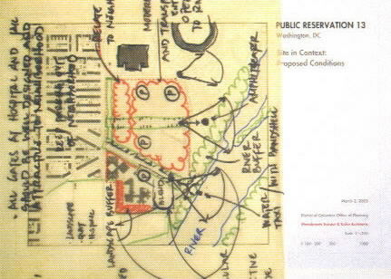 |
 Figure 25 - Two sketches from the Public Workshop, March 2, 2002 |
Many ideas emerged both at public meetings and outside of them that helped to inform the planning process. These ideas are captured below.
Ideas from the Community on Land Uses
John A. Koskinen, Committee Chair, Deputy Mayor/City Administrator
Margret Kellems, Deputy Mayor for Public Safety and Justice
Andrew Altman, Director, DC Office of Planning
Theodore Gordon, Senior Deputy Director for Public Health Assurance,
Department of Health
John S. Henley, PE, Director of Facilities, DC Department of Corrections
Uwe Brandes, Executive Committee Secretary, DC Office of Planning
Andrew Altman, Chair, Director, DC Office of Planning
Karina Ricks, Steering Committee Secretary, Ward 6 Community Planner, DC
Office of Planning
Maxine Brown-Roberts, Development Review Specialist, DC Office of Planning
Timothy Dimond, Director, DC Office of Property Management
Bill Dow, Director, Office of Plans Review, National Capital Planning
Commission
Patricia Gallagher, Executive Director, National Capital Planning
Commission
Linda Donovan Harper, Congressional Cemetary
John S. Henley, PE, Director of Facilities, DC Department of Corrections
Kenan Jarboe, Chair, Advisory Neighborhood Commission 6B
Brenda Kelly, Policy Chief, Environmental Health Administration, DC
Department of Health
Daniel Knise, Chair, Washington 2012 Olympic Bid Committee
Ken Laden, Associate Director for Transportation Policy and Planning, DC
Department of Transportation
Robert Nevitt, President, Capitol Hill Restoration Society
Sia Mullen, Resident, Stadium Armory Neighborhood Association
Eric Rogers, Office of Councilmember Sharon Ambrose
Robert Vowels, MD, MPH, Supervisory Medical Officer, DC Department of
Health
Frank Zampatori, Resident, Stadium Armory Neighborhood Association
Ehrenkrantz Eckstut & Kuhn Architects, PC
Stanton Eckstut, FAIA, Principal-in-Charge
Matthew Bell, AIA, Senior Urban Designer and Project Manager
Matthew Sean O'Donnell, Project Designer
Jeff A. Evans, Project Designer
Leo Varone, Project Designer
Christine Olson, Project Assistant
Office of Planning
Francisca Rojas, Project Planner
Justice & Sustainability Associates, LLC
Mencer Donahue Edwards, Principal-in-Charge
Laura Grambling, Project Assistant
Hadiah Jordan, Project Assistant
![]()
Send mail with questions or comments to webmaster@dcwatch.com
Web site copyright ©DCWatch (ISSN 1546-4296)


